퍼스 도로 중 교통사고 발생 건수가 가장 많은 지역 공개
The Perth roads with the highest number of crashes revealed
Sydney Morning Herald
· 🇦🇺 Sydney, AU
Holly Thompson
EN
2026-05-01 04:00
Translated
조사 결과는 각 위치에서 100미터 반경 내에서 발생한 교통사고를 함께 집계한 공개 가능한 교통사고 데이터 분석을 기반으로 합니다.
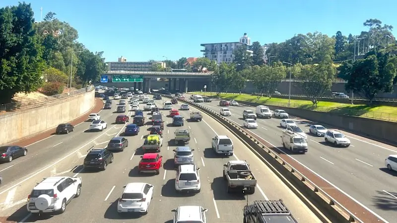
퍼스의 주요 고속도로가 주 내에서 가장 위험한 도로 중 하나로 평가되면서 서호주 전역의 도로 사망자 수가 계속 증가하고 있습니다.
Reid Highway는 온라인 상호작용형 데이터 지도인 CrashDash에 따르면 92.60의 위험도 점수를 받았으며, 2021년 1월부터 2023년 12월까지(가장 최신의 이용 가능한 정보) 4건의 심각한 교통사고와 79건의 경미한 교통사고가 기록되었습니다.
최근 2026년 1월에는 한 남성이 사망하고 어린이를 포함한 3명이 이 고속도로에서 발생한 끔찍한 교통사고 후 병원으로 급송되었습니다.
CrashDash의 데이터에 따르면 3년 기간 동안 WA는 총 22,345건의 교통사고, 즉 하루에 20건 이상의 사고를 기록했습니다.
이 중 17,997건은 경미한 사고(최악의 경우 현장에서 의료 처치를 받음), 4,001건은 심각한 것(한 명 이상이 입원 치료 필요)으로 분류되었으며, 451건은 치명적이었습니다.
주 전역에서 승용차가 사건의 대다수인 95%를 차지했으며, 그 다음 오토바이 관련 8%, 자전거 관련 5%, 보행자 관련 4%였습니다.
Great Eastern Bypass와 Roe Highway의 교차로는 문제가 있는 지역으로 두드러졌으며, 1건의 치명적 사고, 2건의 심각한 사고, 21건의 경미한 사고가 한 지역에서 기록되었습니다.
Great Eastern Highway와 Old Northam Road의 교차로는 2건의 사망사고를 기록했습니다.
이 링크를 따라 서호주의 도로 수준별 교통사고 데이터를 확인하세요.
CrashDash 제작자 Anthony Aisenberg는 각 위치에 대한 위험도 점수가 그 지역에서 기록된 교통사고의 수와 심각도에 기반하며, 치명적인 교통사고에 가장 높은 가중치가 부여된다고 말했습니다.
조사 결과는 공개적으로 이용 가능한 주 정부 교통사고 데이터 분석을 기반으로 하며, 각 위치에서 100미터 반경 내에서 발생한 모든 교통사고를 함께 집계합니다.
"교통사고 데이터가 공개되어 있지만 가시성이 없고 접근 권한을 얻기 위해 매우 복잡합니다"라고 Aisenberg는 말했습니다.
"각 주마다 자신의 웹사이트가 있으며, 종종 데이터 전문 지식과 지리공간 소프트웨어 경험이 필요합니다."
그는 이 웹사이트가 호주 전역의 교통사고에 대한 도로 수준의 데이터를 볼 수 있도록 데이터를 제시하며, 교통사고의 시간, 원인, 관련된 도로 이용자 유형에 대한 상세한 데이터를 표시한다고 말했습니다.
WA는 2026년 4월 27일까지 64명의 사망자를 기록했으며, 이는 2021년부터 2023년 사이 같은 기간에 각각 55명, 48명, 49명의 사망자와 비교됩니다.
RAC 커뮤니케이션 담당 Rhys Heron은 도로 외상이 WA에서 계속 주요 문제라고 말하며, "너무 많은 사람들이 우리의 도로에서 생명을 잃거나 심각한 부상을 당하고 있습니다"라고 말했습니다.
"지난해 퍼스 대도시권은 10년 만에 가장 높은 수준의 도로 사망자를 기록했으며, 올해 지금까지 대도시권은 더욱 악화되고 있습니다"라고 그는 말했습니다.
"도로가 설계, 건설 및 유지되는 방식은 도로 안전에 주요 역할을 하며, 우리가 사용하는 차량의 안전 기능과 모든 도로 이용자의 개인적 행동도 마찬가지입니다.
"안전 인프라에 대한 지속적인 정부 투자가 중요합니다.
"모든 서호주 주민도 속도를 줄이고, 산만함을 없애며, 피곤하거나 영향을 받은 상태에서 운전이나 라이딩을 하지 않음으로써 즉각적인 차이를 만들 수 있습니다."
하루의 가장 중요하고 흥미로운 이야기, 분석 및 인사이트의 요약으로 하루를 시작하세요.
저장된 항목의 최대 개수에 도달했습니다.
더 많은 항목을 추가하려면 저장된 목록에서 항목을 제거하세요.
처리 완료
3,422 tokens · $0.0097
기사 수집 완료 · 04:07
매체 피드에서 기사 메타데이터 수집
헤드라인 번역 완료 · 04:15
제목/요약 한국어 번역 (fetch 시점 inline)
claude-haiku-4-5-20251001
189 tokens
$0.00047
1.4s
본문 추출 완료
3,378자 추출 완료
본문 한국어 번역 완료 · 04:15
1,839자 번역 완료
claude-haiku-4-5-20251001
3,233 tokens
$0.00919
14.5s
지정학적 엔티티 추출 완료 · 04:15
8개 엔티티 추출 완료
지정학적 맥락 & R-Scanner
R-Scanner · 평상
z=0.11
일상적인 보도 수준 — 기준: Perth
(🇦🇺 AU)
최근 6시간 19건
7일 평균 18.5건 / 6h
3개국 매체
3개 매체
본문에서 추출된 지명 (8)
Perth
🇦🇺
Western Australia
🇦🇺
Reid Highway
🇦🇺
Great Eastern Bypass
🇦🇺
Roe Highway
🇦🇺
Great Eastern Highway
🇦🇺
Old Northam Road
🇦🇺
Australia
🇦🇺
위치 지도
지도 로딩 중…
같은 주제의 다른 기사 (최근 7일)
The findings are based on analysis of publicly available crash data that groups together traffic incidents that occurred within a 100-metre radius of each location.
A major Perth highway has been deemed one of the most dangerous in the state, as the number of fatalities on roads across Western Australia continues to increase.Reid Highway received a risk score of 92.60 according to CrashDash, an online interactive data map, with four serious crashes and 79 minor crashes recorded between January 2021 and December 2023 – the latest information available.
More recently, in January 2026, a man died and three others, including a child, were rushed to hospital following a horrific crash along the highway.
The data from CrashDash shows that WA recorded 22,345 crashes in total, or more than 20 per day, across the three-year timeframe.
Of those, 17,997 were minor where at worst someone received medical attention at the scene, 4001 were categorised as serious with one or more people involved needing hospital treatment, and 451 were fatal.
Across the state, cars were involved in the majority of incidents, at 95 per cent, followed by 8 per cent which involved a motorcycle, 5 per cent with a bike and 4 per cent with pedestrians.
The intersection of the Great Eastern Bypass and Roe Highway stood out as a problematic area, with one fatal, two serious and 21 minor crashes recorded in the one location.
And the intersection of the Great Eastern Highway and Old Northam Road recorded two fatalities.
Follow this link to view street-level crash data for Western Australia.
CrashDash creator Anthony Aisenberg said the risk score for each location was based on the number and severity of crashes recorded there, with fatal crashes given the highest weighting.
The findings are based on analysis of publicly available state government crash data that groups together all the traffic incidents that occurred within a 100-metre radius of each location.
“While crash data is open, it is not visible and it is pretty tricky to gain access to,” Aisenberg said.
“Each state has its own website, and often data expertise and geospatial software experience is necessary.”
He said the website presented the data in a way that allowed people to view street-level data on crashes throughout Australia, showing detailed data on the time of day of crashes, the reasons behind them, and the types of road users involved.
WA has recorded 64 fatalities to April 27, 2026, compared with 55, 48 and 49 fatalities respectively between 2021 and 2023 over the same time frame.
RAC head of communications Rhys Heron said road trauma continued to be a major issue in WA, with “far too many people losing their lives or being seriously injured on our roads”.
“Last year, the Perth metropolitan area recorded its highest level of road deaths in a decade, and so far this year the metro area is tracking worse again,” he said.
“The way roads are designed, built and maintained plays a major role in road safety, as do the safety features of the vehicles we use, and the individual actions of all road users.
“Continued government investment in safer infrastructure is critical.
“Every West Australian can also make an immediate difference by slowing down, ditching distractions, and not driving or riding when tired or under the influence.”
Start the day with a summary of the day’s most important and interesting stories, analysis and insights.
You have reached your maximum number of saved items.
Remove items from your saved list to add more.