조지아주 산불로 수십 개 구조물 파괴, 주지사 발표
Wildfires Destroy Dozens of Structures in Georgia, Governor Says
The New York Times
· 🇺🇸 New York, US
Mark Walker and Amy Graff
EN
2026-04-25 07:22
Translated
가뭄으로 인한 화재가 남부 조지아주와 북부 플로리다에서 수만 에이커를 태웠으며, 관계자들은 한 화재로 인해 자원봉사 소방관이 사망했다고 밝혔다.
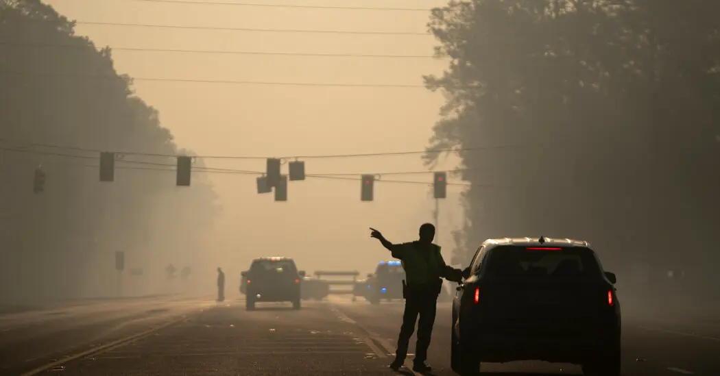
조지아주의 브라이언 켐프 주지사는 금요일 동남부 조지아주의 두 대형 산불이 120개 이상의 구조물을 파괴하고 가뭄으로 황폐해진 수만 에이커의 땅을 불태웠다고 밝혔다. 소방관들은 화재 진압을 위해 노력하고 있다.
이 화재들은 이번 주 남부 조지아주와 북부 플로리다에서 발생한 수십 개의 산불 중 일부이며, 잭슨빌 북서쪽의 한 화재에서는 목요일 불특정 의료 긴급상황 후 자원봉사 소방관이 사망했다고 관계자들이 밝혔다.
조지아주 관계자들은 이 화재들이 주 역사상 어떤 산불보다 더 많은 주택을 태웠다고 믿고 있다. 켐프 주지사는 기자회견에서 약 1,000개의 추가 주택이 위험에 처해 있다고 말했다. 화재로 인한 연기는 웨스트버지니아까지 퍼졌다.
가장 파괴적인 화재는 월요일 브랜틀리 카운티의 82번 고속도로를 따라 시작되었으며, 오키페노키 국립야생동물보호구역 동쪽이자 조지아-플로리다 경계 근처에 위치한다. 화재는 7,500에이커 이상을 태우고 87개의 주택과 다른 구조물을 파괴했다고 켐프 주지사가 말했다. 금요일 화재는 약 15% 진압되었다고 그는 말했다.
"풍선이 전력선에 착륙하여 전기 호가 발생해 화재가 시작되었다고 생각합니다"라고 켐프 주지사가 말했다. 다른 언론은 그 풍선이 어린이 파티의 금속 풍선이라고 보도했다.
야생동물보호구역 반대편 클린치 카운티와 에콜스 카운티의 파인랜드 로드 화재는 31,000에이커 이상을 태우고 35개의 주택을 파괴했다고 켐프 주지사가 말했다. 그 화재는 금요일 아침 약 10% 진압되었다.
"불행히도 우리는 주말 내내 화재 활동이 매우 높을 것으로 예상합니다"라고 켐프 주지사가 말했다. "정말로 우리는 날씨 변화가 필요합니다."
켐프 주지사는 수요일 비상사태를 선포하여 여러 지역사회에서의 대피를 촉발했다. 관계자들은 이번 주 주의 첫 번째 소각 금지를 발표했다.
화재로 인한 연기는 이번 주 동남부 지역 전역으로 퍼졌으며 금요일 애팔래치아 산맥과 웨스트버지니아로 밀려들고 있다.
극심한 가뭄으로 인해 풍경이 건조하고 인화성이 높아지면서 주말에 화재 위협이 증가할 수 있으며 예보에는 뇌우 가능성이 있다.
약화되는 한랭전선이 지역을 통과하면서 토요일 오후부터 저녁까지 가장 높은 뇌우 가능성이 예상되며 일요일 전반부에 걸쳐 지속될 가능성이 있다고 잭슨빌의 국립기상청 사무소의 수석 예보관 알렉스 부스가 말했다.
폭풍은 새로운 화재를 유발하는 번개와 기존 화재를 확산시키는 바람을 초래할 수 있으며, 동시에 폭풍은 비를 가져올 수 있다.
"극심한 가뭄 조건을 감안할 때 우리의 가장 큰 우려는 이 지역의 번개로 인해 더 많은" 화재가 발생할 수 있다는 것입니다"라고 부스가 말했다. "우리는 폭우나 유익한 비를 예상하지 않습니다. 이것은 더 많은 화재를 위한 불행한 상황이 될 수 있습니다."
부스는 지역이 주말에 0.25인치 이하의 비만 올 가능성이 높다고 말했다. 비는 지표면 아래에서 타고 있을 가능성이 높은 화재를 진압하기에 충분한 수분을 제공하지 않을 것이다.
화재가 이렇게 할 때, 지표면 아래에서 타고 있을 가능성이 높은 화재를 진압하기 위해 몇 인치의 비나 물을 펌프질하여 지표면에 주입해야 한다고 미국 남동부 야생지역 화재 서비스의 화재 기상학자 앤디 스나이더가 말했다.
파인랜드 로드와 82번 고속도로 화재 및 남부 조지아주와 북부 플로리다의 수십 개의 더 작은 화재들은 가뭄으로 고통 받는 경관 전역으로 빠르게 확산되었다.
미국 가뭄 모니터 지도는 가뭄을 카운티별로 추적하며, 지도의 가장 높은 수준인 극심한 가뭄에서 예외적 가뭄은 조지아-플로리다 경계를 가로지르고 있다.
플로리다의 가뭄은 지도가 2000년에 도입된 이후 최악이라고 국립가뭄완화센터의 기후학자 브라이언 푹스가 말했다. 조지아의 상황은 2007년과 2000년의 가뭄의 심각성에 접근하고 있다고 푹스가 말했다.
남부 조지아주와 북부 플로리다는 지난 1년간 정상 이하의 강수량을 기록했으며 16~20인치의 결손이 있다.
"우리가 남동부에서 보고 있는 모든 화재 활동은 가뭄으로 인한 연료 기반입니다"라고 스나이더가 말했다. "가뭄이 예외적이기 때문에 늪지와 수로에 물이 없으며, 이것은 일반적으로 확산을 완화하는 방법으로 사용될 수 있습니다."
마크 워커는 속보와 문화를 담당하는 타임스 기자다.
에이미 그래프는 날씨, 산불, 지진을 담당하는 타임스 기자다.
처리 완료
4,213 tokens · $0.0120
기사 수집 완료 · 08:10
매체 피드에서 기사 메타데이터 수집
헤드라인 번역 완료 · 08:25
제목/요약 한국어 번역 (fetch 시점 inline)
claude-haiku-4-5-20251001
233 tokens
$0.00060
2.3s
본문 추출 완료
4,370자 추출 완료
본문 한국어 번역 완료 · 08:25
2,138자 번역 완료
claude-haiku-4-5-20251001
3,980 tokens
$0.01141
23.3s
지정학적 엔티티 추출 완료 · 08:25
8개 엔티티 추출 완료
지정학적 맥락 & R-Scanner
R-Scanner · 평상
z=-1.03
일상적인 보도 수준 — 기준: Georgia
(🇺🇸 US)
최근 6시간 30건
7일 평균 36.29건 / 6h
4개국 매체
5개 매체
본문에서 추출된 지명 (8)
Georgia
🇺🇸
Florida
🇺🇸
Okefenokee National Wildlife Refuge
🇺🇸
Brantley County
🇺🇸
Jacksonville
🇺🇸
West Virginia
🇺🇸
Clinch County
🇺🇸
Echols County
🇺🇸
위치 지도
지도 로딩 중…
같은 주제의 다른 기사 (최근 7일)
Fires fueled by drought have burned tens of thousands of acres in southern Georgia and northern Florida, where officials said one blaze was blamed for the death of a volunteer firefighter.
Gov. Brian Kemp of Georgia said on Friday that two large wildfires in southeast Georgia had destroyed more than 120 structures and scorched tens of thousands of acres of drought-stricken land as firefighters worked to contain them.The fires were among dozens of wildfires that have been burning in southern Georgia and northern Florida this week, including one northwest of Jacksonville where a volunteer firefighter died after an unspecified medical emergency on Thursday, officials said.
Georgia officials said they believed the fires had burned more homes than any wildfire in the state’s history. About 1,000 additional homes remain at risk, Mr. Kemp said at a news conference. Smoke from the fires has spread as far as West Virginia.
The most destructive fire started Monday along Highway 82 in rural Brantley County, east of the Okefenokee National Wildlife Refuge near the Georgia-Florida border, and has since burned more than 7,500 acres and 87 homes and other structures, Mr. Kemp said. The fire was about 15 percent contained on Friday, he said.
“We believe the fire was started by a balloon landing on a power line causing an arc that created the fire,” Mr. Kemp said. Other news outlets reported that the balloon was a metallic one from a child’s party.
The Pineland Road fire in Clinch and Echols Counties, on opposite side of the wildlife refuge, has burned more than 31,000 acres and destroyed 35 homes, Mr. Kemp said. That fire was about 10 percent contained on Friday morning.
“Unfortunately, we believe that fire activity is going to remain extremely high throughout the weekend,” Mr. Kemp said, “and really we need a change in the weather.”
Mr. Kemp declared a state of emergency on Wednesday, prompting evacuations in several communities. Officials announced the state’s first-ever burn ban this week.
Smoke from the fires spread across the Southeast this week and was pushing into the Appalachian Mountains and West Virginia on Friday.
The fire threat could rise over the weekend with a chance of thunderstorms in the forecast, as a weakening cold front moves through the region, where extreme drought has left the landscape dry and flammable.
The highest chance of thunderstorms was expected Saturday afternoon into the evening with a lingering possibility over the first half of Sunday, according to Alex Boothe, the lead forecaster at the National Weather Service office in Jacksonville.
The storms could bring lightning strikes that ignite new fires and winds that spread existing ones, even as the storms bring rain.
“Our biggest concern given the extreme drought conditions is that lightning over the area could lead to more” fires, Mr. Boothe said. “We’re not anticipating a washout or even beneficial rain. This could be one of those unfortunate setups for more fire.”
Mr. Boothe said the region was likely to pick up only about a quarter-inch of rain or less over the weekend. The rain will not bring enough moisture to extinguish fires that have most likely been burning under the surface of the ground.
When fires do this, it requires several inches of rain or pumping water into the ground to put them out, according to Andy Snyder, a fire meteorologist with the U.S. Wildland Fire Service in the Southeast.
The Pineland Road and Highway 82 fires and dozens of smaller ones in southern Georgia and north Florida have spread rapidly across a drought-ridden landscape.
The U.S. Drought Monitor map tracks drought by county, and the highest levels on the map, extreme to exceptional drought, straddle the Georgia-Florida border.
The drought in Florida is the worst since the map was introduced in 2000, according to Brian Fuchs, a climatologist with the National Drought Mitigation Center. The situation in Georgia is approaching the severity of droughts in 2007 and 2000, Mr. Fuchs said.
Southern Georgia and northern Florida recorded below-normal precipitation over the last year, with deficits of 16 to 20 inches.
“All the fire activity we’re seeing in the Southeast is fuel-driven because of the drought,” Mr. Snyder said. “Because the drought is exceptional, there’s no water in the swamps and waterways, and that can usually be used as a way to mitigate the spread.”
Mark Walker is a Times reporter who covers breaking news and culture.
Amy Graff is a Times reporter covering weather, wildfires and earthquakes.