주말에 바람과 소나기가 돌아오며 기온 급락
Wind and showers return this weekend as temperatures tumble
BBC News
EN
2026-04-11 18:12
Translated
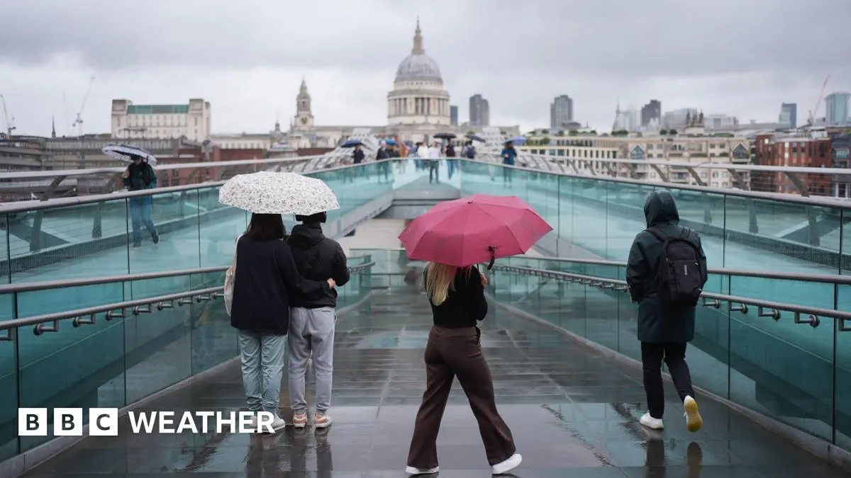
이번 주 비정상적으로 따뜻한 날씨 이후, 주말에는 4월식 날씨 변화로 기온이 내려가고 소나기가 예보되어 있습니다.
영국의 일부 지역에서는 주말 동안 햇빛, 뇌우, 우박, 강풍이 모두 불 수 있습니다.
이는 수요일 영국의 80년 만에 가장 따뜻한 4월 초 날씨 이후 급격한 변화입니다. 당시 런던의 기온은 26.6℃에 도달했습니다.
저기압이 확실히 자리 잡으면서 불안정하고 변덕스러운 날씨가 나타날 것입니다.
기온은 4월 중순의 평균 기온 정도가 될 것입니다.
서쪽에서 영국으로 접근하는 소용돌이치는 저기압은 이동 속도가 느려져 전국에 빗줄기를 퍼뜨릴 것입니다.
토요일 초반의 빗줄기는 결국 모든 지역에서 걷혀 햇빛과 '4월 소나기'가 섞여 나타날 것입니다.
일부 집중호우는 심할 것으로 예상되며, 특히 스코틀랜드, 북아일랜드, 영국 북부, 웨일스에서 우박과 천둥의 가능성이 있습니다.
600m(2000피트) 이상의 높이의 영국 북부와 스코틀랜드의 매우 높은 지역에서는 일부 소나기에 눈이 섞일 것입니다.
하지만 계속 비가 내릴 것은 아니며, 빗줄기 사이에 건조한 간격이 있을 것입니다.
바람이 많이 불 것이며, 특히 서쪽 해안 근처에서는 돌풍이 불 가능성이 있어 서늘함을 더할 것입니다.
최고 기온은 8~14℃(46~57℉)로 범위가 정해질 것입니다.
토요일 밤에는 강한 바람이 계속되다가 일요일에 영국과 웨일스에서 약간 약해질 것입니다.
주말 후반에는 햇빛이 나다가도 소나기가 불어닥칠 것이며, 가장 광범위한 집중호우는 영국 서부에 있고 더 동쪽에서는 약간 건조한 조건이 있을 것입니다.
토요일보다 약간 더 따뜻하게 느껴질 수 있으며, 대부분의 지역에서 기온이 10℃ 이상에 도달할 것입니다.
영국의 많은 지역에서 꽃가루 수치는 높거나 매우 높을 것입니다.
건초열 시즌에 대해 알아야 할 사항
앞으로 며칠간 영국에 영향을 미치는 더 차갑고 불안정한 날씨는 이상하거나 특이할 것이 없습니다.
이번 주 초에 있었던 기온이 비정상적이었으며, 어떤 경우에는 계절 평균보다 10℃(18℉) 이상 높았습니다.
수요일의 26.6℃(79.9℉)(큐 가든)는 4월 첫 번째 반기 동안 영국에서 기록된 두 번째로 높은 기온이었습니다.
따뜻함은 대륙 유럽에서 오는 남쪽 바람의 흐름으로 인해 발생했으며, 기온이 빠르게 상승했습니다.
영국의 4개 지역 각각이 지금까지의 올해 가장 따뜻한 날씨를 경험했습니다.
그 바람의 방향은 이제 변했으며, 대서양에서 오는 대체로 서쪽 흐름이 있습니다. 따라서 훨씬 더 서늘함을 느끼고 '정상적인' 봄 날씨로 돌아갑니다.
기온은 다음 주의 첫 번째 부분 동안 약간 상승할 것으로 예상되지만, 때때로 비가 내릴 것입니다.
얼마나 따뜻해질지에 대해 불확실성이 있습니다.
현 단계에서, 며칠 전에 있었던 매우 높은 기온으로의 복귀는 가능성이 낮아 보이지만, 세부 사항은 변할 수 있습니다.
BBC 날씨 웹사이트와 앱에서 지역 예보로 최신 정보를 유지할 수 있으며, 월간 전망으로 장기 전망을 확인할 수 있습니다.
'슈퍼 엘니뇨'가 오고 있으며 영국에 어떤 영향을 미칠까요?
봄은 영국에서 '가장 빠르게 따뜻해지는' 계절입니다
봄 밤하늘을 밝힐 천문 현상들
처리 완료 3,241 tokens · $0.0091
기사 수집 완료 · 23:50
매체 피드에서 기사 메타데이터 수집
헤드라인 번역 완료 · 00:06
제목/요약 한국어 번역 (fetch 시점 inline)
claude-haiku-4-5-20251001
187 tokens
$0.00044
1.8s
본문 추출 완료
3,071자 추출 완료
본문 한국어 번역 완료 · 00:06
1,512자 번역 완료
claude-haiku-4-5-20251001
3,054 tokens
$0.00862
16.1s
지정학적 엔티티 추출 완료 · 00:06
8개 엔티티 추출 완료
After a brief spell of unusually warm weather this week, the weekend brings an April weather reset with a return to lower temperatures and showers in the forecast.
Sunshine, thunderstorms, hail, and strong winds - parts of the UK are likely to see it all over the weekend.This marks an abrupt change after the UK's warmest early-April day in 80 years on Wednesday, when temperatures peaked at 26.6C in London.
With low pressure firmly in charge it is going to be unsettled with changeable conditions.
And, temperatures will be more like the average for mid-April.
The swirling area of low pressure approaching the UK from the west, will become slow-moving, throwing bursts of wet weather across the country.
Early rain on Saturday will eventually clear from all parts to leave a mixture of sunny spells and 'April showers'.
Some of the downpours will be heavy, with the chance of hail and thunder, particularly in Scotland, Northern Ireland, northern England and Wales.
Snow will mix in with some of the showers across very high ground in northern England and Scotland, above 600m (2000ft) elevation.
However, it will not be raining all the time, with dry interludes between the spells of rain.
It will be windy, especially around western coasts where gales are possible, adding to a chilly feel.
Maximum temperatures will range from 8 to 14C (46-57F).
Winds will remain strong on Saturday night before easing a little on Sunday for England and Wales.
Sunny spells and blustery showers will continue for the second half of the weekend, with the most widespread downpours in the west of the UK and slightly drier conditions further east.
It may feel slightly warmer than Saturday, with temperatures reaching double digits in most locations.
Pollen levels will remain high or very high for many areas of England.
What you need to know about hayfever season
There is nothing strange or unusual about the cooler and more unsettled weather affecting the UK over the next few days.
It is the temperatures we had earlier in the week that were out of the ordinary, in some cases more than 10C (18F) above the seasonal average.
Wednesday's 26.6C (79.9F) at Kew Gardens, was the second-highest temperature recorded in the UK during the first half of April.
The warmth came courtesy of a flow of southerly winds from continental Europe, which caused temperatures to climb rapidly.
Each of the four UK nations saw the warmest weather of the year so far.
That wind direction has now changed, with a broadly westerly flow from the Atlantic - hence the significantly cooler feel and a return to "normal" spring weather.
Temperatures are expected to climb a little during the first part of next week, albeit with some outbreaks of rain at times.
There is some uncertainty about how warm it might get.
At this stage, a return to the very high temperatures we had a few days ago looks unlikely, but details could change.
You can keep up to date with your local forecast on the BBC Weather website and app, and check the longer term prospect with our monthly outlook.
Is a 'Super El Niño' on the way and how will it affect the UK?
Spring is 'fastest-warming' season in the UK
Celestial events to light up the spring night sky