날씨: 사이클론 바이아누가 접근하면서 토요일 아침에 첫 영향을 받을 수 있음
Weather: First impacts could be felt Saturday morning as Cyclone Vaianu nears
RNZ
EN
2026-04-10 16:29
Translated
북섬 전역에서 붉은색과 주황색 경보가 발령되었으며 사이클론 바이아누의 경로가 더욱 명확해지고 있습니다.
사이클론 바이아누가 뉴질랜드에 접근하면서 이번 주말에 심각한 날씨 경보가 발령될 예정입니다.
코로만델과 플렌티만의 일부 지역이 가장 피해를 입을 것으로 예상되지만, 북섬의 어느 곳도 피해를 피할 수 없을 것으로 예보관들은 경고하고 있습니다.
오후 5시 기준으로 지역 대응의 일환으로 노스랜드에 대해 초기 7일간의 긴급 상황이 선포되었습니다.
첫 경보는 토요일 밤 늦게 노스랜드에서 발효되며, 바이아누는 남쪽으로 이동할 것입니다.
대부분의 강우와 바람은 일요일에 닥칠 것이며, 이른 오후까지 남섬 상부에 도달할 것입니다.
MetService 기상학자 존 로우는 Checkpoint와의 인터뷰에서 토요일 아침에 북동부 지역에서 큰 파도로 시스템의 첫 영향을 느낄 수 있다고 말했습니다.
"이것은 다중 위험 저기압 시스템입니다. 강한 바람이 바다 위로 불면서 개방된 해역 전역에서 큰 파도를 일으키고, 북서쪽에서 밀려옵니다. 노스랜드와 플렌티만 같은 북부 해안 지역에서는 파도의 높이가 6~8미터에 달할 수 있습니다. 여기에 강을 따라 내려오는 습한 날씨, 강한 바람, 저기압으로 인한 추가 해수 상승, 그리고 해안 지역의 영향이 더해지면 그 위험도는 증가합니다."
로우는 또한 북섬 전체가 날씨 주의보와 경보 대상이 되는 것은 "매우 드물다"고 말했습니다.
"일반적으로 우리의 주의보와 경보는 가능한 한 작은 지역으로 제한하여 영향을 받는 지역에 집중하려고 합니다. 따라서 전체 섬이 이런 심각한 날씨 주의보와 경보를 받고 있다는 사실은 이 시스템의 심각성, 즉 습한 날씨뿐만 아니라 바람의 심각성을 나타내는 지표입니다. 바람이 이번 주말을 통해 핵심 특징이 될 것 같습니다.
"이 시스템이 우리를 지나가면서 바람의 방향이 바뀔 것입니다... 처음에는 북풍이 불지만, 시스템이 남쪽으로 밀려가면서 강한 남풍 또는 서풍이 뒤따를 것입니다. 그래서 이 방향 변화도 주의해야 할 사항입니다."
그는 사람들에게 Civil Defence의 경보와 조언을 최신으로 유지할 것을 촉구했습니다.
"강한 바람은 물건을 들어올려 날려보낼 수 있으며, 사람과 재산에 피해와 위험을 초래할 수 있지만, 특히 생명의 위험이 있습니다. 정원에 물건이 있다면 그것들을 고정하고, 그 강력한 바람에 날려다닐 수 있는 위험한 것이 없도록 해야 합니다."
토요일 밤 9시부터 베이 오브 아일즈 남쪽과 호키앙가 하버까지 노스랜드에 대한 주황색 폭우 경보가 발령되어 있습니다.
노스랜드 Civil Defence 컨트롤러 다미안 리오는 지역 전체 긴급 선언이 노스랜드에서는 드물지만 사이클론 바이아누의 잠재적 중대 영향을 고려한 예방 조치라고 말했습니다.
리오는 긴급 상황 선언이 당국에 대피 명령, 도로 폐쇄, 건물 진입 금지, 장비 또는 물품 징수 권한을 부여한다고 말했습니다.
오클랜드, 그레이트 배리어 아일랜드, 코로만델 반도, 와카타네 서쪽의 플렌티만(로토루아 포함), 톨라가 베이 북쪽의 기즈본/타이라와이티도 모두 일요일 이른 시간부터 주황색 폭우 경보 대상입니다.
긴급 관리 및 회복 장관 마크 미첼은 이것이 잠재적으로 심각하고 파괴적인 폭풍이 될 것이라고 말했으며, Earth Sciences NZ는 북섬 상부 일부 지역에서 200mm 이상의 강우량이 떨어질 수 있다고 예측했습니다.
노스랜드에는 토요일 밤 11시부터 일요일 오후까지 주황색 강풍 경보가 발령되어 있습니다. 오클랜드, 와이카토, 와이토모, 타우포, 타우마루누이, 플렌티만과 로토루아, 기즈본/타이라와이티, 호크스 베이, 타이하페, 타라나키, 왕가누이도 모두 토요일 밤에 발효되는 주황색 경보 대상입니다.
오클랜드 주민들은 강풍으로 인해 하버 브릿지가 폐쇄될 수 있다는 경고를 받았습니다.
"강풍은 돌풍이 차량을 다리 구조물 또는 다른 차량의 경로로 불어날 위험을 야기합니다"라고 해당 기관이 금요일 오후 성명에서 말했습니다.
"운전자들은 풍속이 너무 높아지면 다리가 완전히 폐쇄될 수 있음을 예상해야 합니다. 또한 차선 폐쇄 및 제한 속도가 시행될 가능성이 높습니다."
다리가 폐쇄되면 운전자들은 국도 16과 18 주변으로 우회해야 합니다.
여러 버스 노선이 다리를 통과하므로, 버스가 우회하거나 취소될 경우 지연이 발생할 수 있습니다.
일요일 해밀턴에서 열릴 예정이었던 FIFA 월드컵 예선전이 최악의 상황을 피하기 위해 토요일로 앞당겨졌습니다.
관계자들은 참가자와 경기장을 방문하는 팬들의 안전을 보장하기 위해 이 결정을 내렸다고 말했습니다.
Football Ferns와 피지 간의 오세아니아 준준결승전과 파푸아뉴기니(PNG)와 아메리칸 사모아 간의 경기가 원래 일요일 오후 해밀턴에서 예정되었습니다.
이제 토요일에 경기가 진행될 예정이며, PNG가 정오에 아메리칸 사모아와 경기하고 뉴질랜드가 오후 4시에 피지와 경기합니다.
MetService 대변인 헤더 키츠는 코로만델에서 140km/h의 돌풍이 예상된다고 말했지만, 매우 강한 배경 바람도 올 것이라고 했습니다.
"바이아누는 바람과 위험한 해상 조건으로 기억될 것입니다."
MetService는 "배수로와 우수관을 정소하여 폭우에 대비하세요. 저지대를 피하고 주의 깊게 운전하세요"라고 경고했습니다.
"날아오는 물체와 나무가 떨어질 위험으로부터 생명의 위협. 파괴적인 바람은 전력선과 지붕을 포함한 광범위한 손상을 야기하며, 위험한 운전 조건과 교통 및 전력 공급의 중대한 중단을 초래할 것입니다."
통신 제공업체 Spark는 "가능한 한 빨리" 정전 또는 장비 손상에 대응할 준비가 된 추가 직원을 보유하고 있다고 말했습니다.
"우리는 핵심 지역에 휴대용 위성 백업 옵션(Starlink 장치 포함)을 전략적으로 배치했습니다"라고 Spark는 소셜 미디어 게시물에서 말했으며, "배포 가능한 이동식 셀 타워(COW)도 전략적으로 배치했으며, 필요한 경우 추가 위성 지원을 제공하여 가장 필요한 지역에서 커버리지를 복구할 수 있습니다"라고 덧붙였습니다.
Earth Sciences New Zealand는 오클랜드 지역이 12시간 내에 한 달치 강우량을 받을 수 있다고 말했습니다. 수석 과학자 크리스 브란돌리노는 Morning Report에 엄청난 양의 비가 예보되고 있으며 코로만델 지역의 일부 장소는 산맥에서 약 200mm의 강우량을 볼 수 있다고 말했습니다.
남섬도 피하지 못했으며, 말버러 사운드와 카이코우라 북쪽의 북동부 지역을 포함한 폭우 주의보가 발령되어 있습니다.
RNZ는 뉴질랜드의 법정 civil defence 라이프라인 라디오 방송사입니다. 이는 RNZ가 긴급 상황 중 방송과 온라인을 통해 중요한 정보와 업데이트를 제공한다는 의미입니다.
해당 지역의 라디오 주파수를 찾고 여기에서 준비하세요.
처리 완료 5,835 tokens · $0.0166
기사 수집 완료 · 17:20
매체 피드에서 기사 메타데이터 수집
헤드라인 번역 완료 · 18:36
제목/요약 한국어 번역 (fetch 시점 inline)
claude-haiku-4-5-20251001
200 tokens
$0.00049
2.1s
본문 추출 완료
6,986자 추출 완료
본문 한국어 번역 완료 · 18:36
3,291자 번역 완료
claude-haiku-4-5-20251001
5,635 tokens
$0.01609
35.9s
지정학적 엔티티 추출 완료 · 18:36
8개 엔티티 추출 완료
Red and orange warnings have been issued across the North Island as the path of Cyclone Vaianu becomes clearer.
Severe weather warnings are set to come into place this weekend as Cyclone Vaianu bears down on the country.Coromandel and parts of the Bay of Plenty are expected to be the worst-affected, though no part of the North Island will escape unscathed, forecasters warn.
A state of emergency has been declared for Northland as at 5pm, for an initial period of seven days, as part of the regional response.
The first warnings will be in effect from late Saturday night in Northland, before Vaianu makes its way south.
Most of the rain and winds will hit on Sunday, reaching the upper South Island by early afternoon.
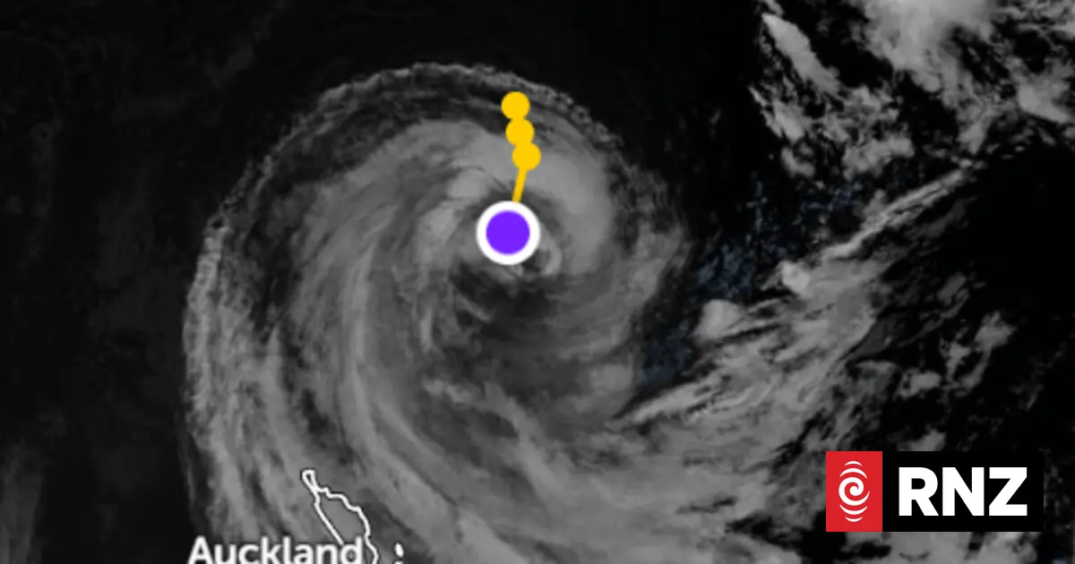
Satellite image of Vaianu showing the potential track as it heads towards New Zealand.
Photo: Zoom Earth
MetService meteorologist John Law told Checkpoint the first impacts of the system could be felt on Saturday morning with large swells for north-eastern areas.
"This is a multi-hazard area of low pressure that runs down. You can imagine that these strong winds rushing over the seas help to drive large swells across the open waters, and they run in from the northwest. And I think around those northern coasts, places like Northland and the Bay of Plenty, swell heights could be as much as six to eight metres. Now, adding to that, the wet weather coming down the rivers, the strong winds, the extra boost of that sea by the extra low pressure, those coastal eliminations, that risk does increase."
Law also said it was "very unusual" to see the entire North Island under weather watches and warnings.
"Normally our watches and warnings, we try and keep them to as small an area as possible to kind of really focus in on those areas impacting. So the fact that the whole island has got these severe weather watches and warnings… it is an indication of the severity of the system coming through, not just in terms of the wet weather, but that wind, I think, is going to be one of the key features as we head through the weekend.
"As this system runs across us, we'll find our winds changing direction... as they come in to start with we're looking at northerly winds, but as the system sweeps down to the south, strong south or westerly winds behind it will also be another issue. So that change in direction, something else to keep in mind."
He urged people to stay up to date with warnings and advice from Civil Defence.
"Strong winds can cause things to be picked up and blown around, and they can cause damage and danger to people and possessions, but particularly that risk of life. So if you've got something in the garden, you want to tie it down, make sure things don't become dangerous by flying around in those incredibly strong winds."
An orange heavy rain warning is in place for Northland about and south of Bay of Islands to Hokianga Harbour from 9pm Saturday night.
Northland Civil Defence controller Damian Rio says region-wide emergency declarations are rare in Northland, but is a precaution given the potentially significant effects from Cyclone Vaianu.
Rio said the State of Emergency gives authorities the power to order evacuations, close roads, entre premises, and requisition equipment or supplies.
Weather warnings ahead of Cyclone Vaianu.
Photo: MetService
Meanwhile Auckland, Great Barrier Island, Coromandel Peninsula, Bay of Plenty west of Whakatane including Rotorua, and Gisborne/Tairawhiti north of Tolaga Bay are all under an orange heavy rain warning from the early hours of Sunday morning.
Emergency Management and Recovery Minister Mark Mitchell says it will be a potentially significant and damaging storm, and Earth Sciences NZ predicted more than 200mm of rain could fall in some places across the upper North Island.
An orange strong wind warning is in place for Northland from 11pm Saturday until Sunday afternoon. Auckland, Waikato, Waitomo, Taupo, Taumarunui, Bay of Plenty and Rotorua, Gisborne/Tairawhiti, Hawke's Bay, Taihape, Taranaki and Wanganui are all also under orange warnings which come into place overnight Saturday.
Aucklanders have been warned the Harbour Bridge might close due to strong winds.
"High winds create a risk that gusts of wind may blow vehicles into the bridge structure or the path of other vehicles," the agency said in a statement on Friday afternoon.
"Drivers should expect the bridge may need to be fully closed if wind gusts get too high. It is also likely that there will be lane closures and reduced speed limits in place."
If the bridge is closed, drivers will need to detour around State Highways 16 and 18, it said.
Several bus routes cross the bridge, which may mean delays if buses are detoured or cancelled.
Cyclone Vaianu is forecast to reach NZ by Saturday.
Photo: Earth Nullschool
FIFA World Cup qualifying matches due to be played in Hamilton on Sunday have been brought forward to Saturday to avoid the worst of it.
Officials said the decision was made to ensure the safety of participants and fans attending the games.
The Oceania semi-finals between the Football Ferns and Fiji and Papua New Guinea (PNG) and American Samoa were originally scheduled for Sunday afternoon in Hamilton.
They will now be played Saturday, with PNG playing American Samoa at midday and New Zealand playing Fiji at 4pm.
MetService spokesperson Heather Keats said gusts of 140 km/h were expected to hit the Coromandel, but there was also very strong background wind to come.
"Vaianu is going to be remembered for its wind, for its dangerous sea conditions."
"Clear your drains and gutters to prepare for heavy rain. Avoid low-lying areas and drive cautiously," Metservice warned.
"Threat to life from flying items and falling trees. Destructive winds will cause widespread damage including powerlines and roofs, with dangerous driving conditions and significant disruption to transport and power supply."
Telecommunications provider Spark said it had extra crews ready to work through any power cuts or equipment damage "as quicly as we safely can".
"We've strategically placed portable satellite back-up options (including Starlink units) in key areas," Spark said in a social media post adding they have also "strategically positioned deployable Cell Towers on Wheels (COWs), and we can bring in extra satellite support if needed, to help restore coverage where it's most needed".
Earth Sciences New Zealand said the Auckland region could see over a month's worth of rain in 12 hours. Principal scientist Chris Brandolino told Morning Report a tremendous amount of rain was forecast, and places in the Coromandel region could see about 200mm about the ranges.
Not even the South Island is spared, with a heavy rain watch in place for Marlborough Sounds, including northeastern areas north of Kaikoura.
RNZ is New Zealand's statutory civil defence lifeline radio broadcaster. That means RNZ will provide vital information and updates as they come to hand on air and online during an emergency.
Find the radio frequency for your area here and get prepared here.