가뭄으로 수위가 낮아진 파웰 호수로 물이 유입되지만 다른 곳에서는 대가가 따른다
Water to surge into drought-depleted Lake Powell but at costs elsewhere
Associated Press
· 🇺🇸 New York, US
https://apnews.com/author/mead-gruver
EN
2026-04-23 13:25
Translated
포트 콜린스, 콜로라도 (AP) — 동부 유타의 협곡들은 이번 봄에 엄청난 양의 물 — 화장실 5만 개가 동시에 계속 내려가는 것과 같은 양 — 로 소용돌이칠 것이다. 미국 서부 대부분의 수천 가구에 전기를 공급하기 위해 그린 강과 콜로라도 강의 유량이 엄청날 것으로 보인다.
그린강과 콜로라도강의 유량은 사막의 사암 아치와 가시 선인장이 많은 건조한 지역에서 풍부한 수분으로 보일 수 있지만, 실제로는 그 반대다.
기록상 가장 건조한 겨울 이후, 관계자들은 이번 봄에 콜로라도 강의 심각하게 고갈된 파웰 호수의 수위를 높여 수력발전을 계속 가동하려고 한다. 이를 위해 그들은 궁극적으로 와이오밍과 유타의 그린 강 상류 플레밍 고지 저수지의 물의 최대 3분의 1을 방출할 계획이며, 이는 전기 공급을 유지했던 2022년의 기록적인 방출을 초과할 것이다.
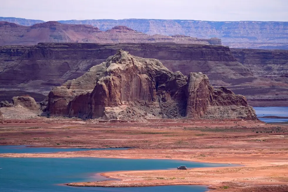
글렌 캐니언 댐이 막고 있는 파웰 호수는 미국 서부 35만 가구 이상에 저렴하고 탄소 없는 전기를 공급한다. 하지만 목장주, 산업, 그리고 약 4천만 명의 주택 수도 고객에 의해 크게 의존하는 분쟁이 있는 강 유역의 다른 곳에서는 점점 더 많은 대가를 치르고 있다.
남서부 와이오밍의 플레밍 고지에서 벅보드 마리나 소유주 토니와 젠 발데스는 방출로 인해 수위가 여름 늦게까지 10피트(3미터) 하락할 것으로 예상되고 있다. 보트를 내릴 수 있는 물의 가장자리까지 가는 길이 더 길어질 것을 의미한다.
"물론 우리는 우려하고 있다"고 젠 발데스가 말했다. "그리고 우리가 더 우려해야 할 지점에 도달할 것 같다."
모든 일이 계획대로 진행되고 날씨로부터 해제되지 않는다면, 플레밍 고지는 1년 후 최대 27피트(8미터)가 하락할 것이며, 벅보드 마리나를 훨씬 더 악화시킬 것이다.
이것이 장기 가뭄 속에서 일시적인 해결책일 가능성이 높지만, 다운스트림에도 영향이 있을 것이다. 미국 재정복구국 수자원 관리자들은 애리조나-유타 경계의 파웰 호수에서 흘러나가는 물보다 통상적으로 더 많은 물을 유지할 계획이기 때문이다.
다운스트림에서 라스베이거스 근처의 미드 호수는 4년 전의 저수위와 유사해져 이전에 수몰된 보트와 유골을 드러낼 것으로 예상된다.
연방 관계자들은 파웰 호수의 수위를 발전 터빈을 운영하기에 충분히 높게 유지하기 위해 공기가 시스템에 들어가 손상을 일으키지 않도록 하기 위해 이러한 급진적인 조치가 필요하다고 말한다.
도시와 부족부터 시골 전기 협동조합과 공공 유틸리티 지구까지, 약 155명의 고객이 글렌 캐니언 댐 및 기타 연방 발전소에서 수력발전 전기를 받는다. 어느 것도 수력발전에 100% 의존하지 않는다.
많은 것들이 취약 지역에 있으며 모두 댐을 운영하고 유지하기 위한 비용 및 연방 정부의 투자를 지불하는 비영리 단체다.
연방 서부 지역 전력청은 고객에게 일정 양의 전기를 공급할 계약상 의무가 있다. 수력발전이 감소하면 WAPA는 아마도 더 비싸고 재생 불가능한 다른 곳에서 전력을 찾아야 할 것이라고 비영리 콜로라도 강 에너지 유통업체 협회의 executive director인 Leslie James가 말했다.
"글렌 캐니언 수력발전이 0 또는 낮은 양으로 감소하면, 지역사회에 청구하는 요금에 다양한 영향을 미칠 것이다"고 James가 말했다.
이 상황은 James가 애리조나, 콜로라도, 네바다, 뉴멕시코, 유타, 와이오밍의 전기 고객을 돕기 위해 48년 동안 본 적이 없다고 그녀가 말했다.
연방 수력발전을 시장 구매로 대체하면 솔트레이크시 남동쪽 헤버 라이트 앤 파워에서 지난 5년 동안 요금 인상이 강제되었으며, 최신 인상이 13%에 도달했다고 유틸리티의 에너지 자원 관리자 에밀리 브란트가 말했다.
점점 더 빈번한 가뭄, 증발, 수요 — 특히 소 산업을 위해 알팔파를 관개하기 — 는 파웰 호수의 수위를 해수면 위 3,526피트(1,075미터)로 축소시켰다 — 전체 용량의 단 23%.
발전을 계속하려면 저수지는 3,490피트(1,200미터) 이하로 떨어질 수 없으며, 이는 글렌 캐니언 댐의 전기 발전기를 위한 물 흡입 수위다.
이는 710피트(220미터) 댐이 1963년에 완성되고 파웰 호수가 1980년에 천천히 전체 용량으로 채워진 이후로 발생하지 않았다.
2022년에 재정복구국은 플레밍 고지에서 파웰 호수를 높이기 위해 전례 없는 500,000에이커-피트(6억 1,700만 입방 미터)의 물을 방출했다. 파웰 호수의 발전 생산을 유지하기 위한 최신 플레밍 고지 방출은 궁극적으로 그 양의 2배가 될 수 있다.
한편, 파웰 호수에 150만 에이커-피트(18억 5천만 입방 미터)를 보유하려는 계획은 다운스트림의 훨씬 낮은 미드 호수에서 후버 댐이 40% 적은 전기를 생산하게 될 것이다.
또 다른 단점: 파웰 호수의 표면에서 따뜻한 물은 글렌 캐니언 댐 아래 콜로라도 강에서 위협받는 토착 종인 혹등 농어와 경쟁하는 침입종인 나이 입 배스의 확산을 장려할 수 있다. 그랜드 캐니언 신탁을 포함한 단체들은 수자원 관리자들에게 그랜드 캐니언을 나이 입 배스에 불리한 상태로 유지하기 위해 더 깊고 시원한 물을 섞을 것을 촉구한다.
앞으로 며칠과 몇 주 동안 플레밍 고지의 가장 강력한 방출은 콜로라도 강 지류인 그린 강의 토착 물고기를 돕기 위해 보정될 것이다.
결국 플레밍 고지는 83% 가득 찬 상태에서 추정 59% 가득 찬 상태로 떨어질 것이다. 2022년 플레밍 고지에서의 방출은 습한 겨울이 따라 지역 전체의 수자원 우려를 일시적으로 완화시켰다.
"우리는 어머니 자연에 의해 구해졌다"고 벅보드 마리나 소유주인 발데스가 말했다.
습한 해 하나 또는 둘은 적어도 부분적으로 인간이 초래한 기후 변화로 인한 25년의 "megadrought"를 역전시키기에 충분하지 않을 것이다. 하지만 발데스는 습한 날씨가 이전처럼 돌아올 것으로 낙관하고 있다.
"희망적으로 우리는 다른 것들을 하는 것으로 확장할 수 있다"고 발데스가 말했다. "왜냐하면 그것은 결국 돌아올 것이기 때문이다."
Associated Press는 물과 환경 정책 보도를 위해 Walton Family Foundation으로부터 지원을 받는다. AP는 모든 콘텐츠에 전적인 책임이 있다. AP의 모든 환경 보도는 https://apnews.com/hub/climate-and-environment를 방문하시오.
그린강과 콜로라도강의 유량은 사막의 사암 아치와 가시 선인장이 많은 건조한 지역에서 풍부한 수분으로 보일 수 있지만, 실제로는 그 반대다.
기록상 가장 건조한 겨울 이후, 관계자들은 이번 봄에 콜로라도 강의 심각하게 고갈된 파웰 호수의 수위를 높여 수력발전을 계속 가동하려고 한다. 이를 위해 그들은 궁극적으로 와이오밍과 유타의 그린 강 상류 플레밍 고지 저수지의 물의 최대 3분의 1을 방출할 계획이며, 이는 전기 공급을 유지했던 2022년의 기록적인 방출을 초과할 것이다.
글렌 캐니언 댐이 막고 있는 파웰 호수는 미국 서부 35만 가구 이상에 저렴하고 탄소 없는 전기를 공급한다. 하지만 목장주, 산업, 그리고 약 4천만 명의 주택 수도 고객에 의해 크게 의존하는 분쟁이 있는 강 유역의 다른 곳에서는 점점 더 많은 대가를 치르고 있다.
남서부 와이오밍의 플레밍 고지에서 벅보드 마리나 소유주 토니와 젠 발데스는 방출로 인해 수위가 여름 늦게까지 10피트(3미터) 하락할 것으로 예상되고 있다. 보트를 내릴 수 있는 물의 가장자리까지 가는 길이 더 길어질 것을 의미한다.
"물론 우리는 우려하고 있다"고 젠 발데스가 말했다. "그리고 우리가 더 우려해야 할 지점에 도달할 것 같다."
모든 일이 계획대로 진행되고 날씨로부터 해제되지 않는다면, 플레밍 고지는 1년 후 최대 27피트(8미터)가 하락할 것이며, 벅보드 마리나를 훨씬 더 악화시킬 것이다.
이것이 장기 가뭄 속에서 일시적인 해결책일 가능성이 높지만, 다운스트림에도 영향이 있을 것이다. 미국 재정복구국 수자원 관리자들은 애리조나-유타 경계의 파웰 호수에서 흘러나가는 물보다 통상적으로 더 많은 물을 유지할 계획이기 때문이다.
다운스트림에서 라스베이거스 근처의 미드 호수는 4년 전의 저수위와 유사해져 이전에 수몰된 보트와 유골을 드러낼 것으로 예상된다.
연방 관계자들은 파웰 호수의 수위를 발전 터빈을 운영하기에 충분히 높게 유지하기 위해 공기가 시스템에 들어가 손상을 일으키지 않도록 하기 위해 이러한 급진적인 조치가 필요하다고 말한다.
도시와 부족부터 시골 전기 협동조합과 공공 유틸리티 지구까지, 약 155명의 고객이 글렌 캐니언 댐 및 기타 연방 발전소에서 수력발전 전기를 받는다. 어느 것도 수력발전에 100% 의존하지 않는다.
많은 것들이 취약 지역에 있으며 모두 댐을 운영하고 유지하기 위한 비용 및 연방 정부의 투자를 지불하는 비영리 단체다.
연방 서부 지역 전력청은 고객에게 일정 양의 전기를 공급할 계약상 의무가 있다. 수력발전이 감소하면 WAPA는 아마도 더 비싸고 재생 불가능한 다른 곳에서 전력을 찾아야 할 것이라고 비영리 콜로라도 강 에너지 유통업체 협회의 executive director인 Leslie James가 말했다.
"글렌 캐니언 수력발전이 0 또는 낮은 양으로 감소하면, 지역사회에 청구하는 요금에 다양한 영향을 미칠 것이다"고 James가 말했다.
이 상황은 James가 애리조나, 콜로라도, 네바다, 뉴멕시코, 유타, 와이오밍의 전기 고객을 돕기 위해 48년 동안 본 적이 없다고 그녀가 말했다.
연방 수력발전을 시장 구매로 대체하면 솔트레이크시 남동쪽 헤버 라이트 앤 파워에서 지난 5년 동안 요금 인상이 강제되었으며, 최신 인상이 13%에 도달했다고 유틸리티의 에너지 자원 관리자 에밀리 브란트가 말했다.
점점 더 빈번한 가뭄, 증발, 수요 — 특히 소 산업을 위해 알팔파를 관개하기 — 는 파웰 호수의 수위를 해수면 위 3,526피트(1,075미터)로 축소시켰다 — 전체 용량의 단 23%.
발전을 계속하려면 저수지는 3,490피트(1,200미터) 이하로 떨어질 수 없으며, 이는 글렌 캐니언 댐의 전기 발전기를 위한 물 흡입 수위다.
이는 710피트(220미터) 댐이 1963년에 완성되고 파웰 호수가 1980년에 천천히 전체 용량으로 채워진 이후로 발생하지 않았다.
2022년에 재정복구국은 플레밍 고지에서 파웰 호수를 높이기 위해 전례 없는 500,000에이커-피트(6억 1,700만 입방 미터)의 물을 방출했다. 파웰 호수의 발전 생산을 유지하기 위한 최신 플레밍 고지 방출은 궁극적으로 그 양의 2배가 될 수 있다.
한편, 파웰 호수에 150만 에이커-피트(18억 5천만 입방 미터)를 보유하려는 계획은 다운스트림의 훨씬 낮은 미드 호수에서 후버 댐이 40% 적은 전기를 생산하게 될 것이다.
또 다른 단점: 파웰 호수의 표면에서 따뜻한 물은 글렌 캐니언 댐 아래 콜로라도 강에서 위협받는 토착 종인 혹등 농어와 경쟁하는 침입종인 나이 입 배스의 확산을 장려할 수 있다. 그랜드 캐니언 신탁을 포함한 단체들은 수자원 관리자들에게 그랜드 캐니언을 나이 입 배스에 불리한 상태로 유지하기 위해 더 깊고 시원한 물을 섞을 것을 촉구한다.
앞으로 며칠과 몇 주 동안 플레밍 고지의 가장 강력한 방출은 콜로라도 강 지류인 그린 강의 토착 물고기를 돕기 위해 보정될 것이다.
결국 플레밍 고지는 83% 가득 찬 상태에서 추정 59% 가득 찬 상태로 떨어질 것이다. 2022년 플레밍 고지에서의 방출은 습한 겨울이 따라 지역 전체의 수자원 우려를 일시적으로 완화시켰다.
"우리는 어머니 자연에 의해 구해졌다"고 벅보드 마리나 소유주인 발데스가 말했다.
습한 해 하나 또는 둘은 적어도 부분적으로 인간이 초래한 기후 변화로 인한 25년의 "megadrought"를 역전시키기에 충분하지 않을 것이다. 하지만 발데스는 습한 날씨가 이전처럼 돌아올 것으로 낙관하고 있다.
"희망적으로 우리는 다른 것들을 하는 것으로 확장할 수 있다"고 발데스가 말했다. "왜냐하면 그것은 결국 돌아올 것이기 때문이다."
Associated Press는 물과 환경 정책 보도를 위해 Walton Family Foundation으로부터 지원을 받는다. AP는 모든 콘텐츠에 전적인 책임이 있다. AP의 모든 환경 보도는 https://apnews.com/hub/climate-and-environment를 방문하시오.
처리 완료
5,736 tokens · $0.0153
기사 수집 완료 · 13:25
매체 피드에서 기사 메타데이터 수집
헤드라인 번역 완료 · 13:19
제목/요약 한국어 번역 (fetch 시점 inline)
kimi-k2.5
0 tokens
$0.00000
0.2s
본문 추출 완료
8,072자 추출 완료
본문 한국어 번역 완료 · 13:19
3,094자 번역 완료
claude-haiku-4-5-20251001
5,736 tokens
$0.01527
33.4s
지정학적 엔티티 추출 완료 · 13:19
8개 엔티티 추출 완료
지정학적 맥락 & R-Scanner
R-Scanner · 평상
z=-0.9
일상적인 보도 수준 — 기준: Lake Powell
(🇺🇸 US)
최근 6시간 0건
7일 평균 1.39건 / 6h
0개국 매체
0개 매체
본문에서 추출된 지명 (8)
Lake Powell
🇺🇸
Utah
🇺🇸
Colorado River
🇺🇸
Wyoming
🇺🇸
Green River
🇺🇸
Lake Mead
🇺🇸
Grand Canyon
🇺🇸
Colorado
🇺🇸
위치 지도
지도 로딩 중…
Low water levels at Wahweap Bay at Lake Powell, along the Upper Colorado River Basin are shown, June 9, 2021, at the Utah and Arizona border at Wahweap, Ariz. (AP Photo/Ross D. Franklin, File)
A sign cautioning fluctuating water levels is displayed at Firehole Canyon, on the far northeastern shore of Flaming Gorge Reservoir, Friday, Aug. 5, 2022, in Wyoming. (AP Photo/Rick Bowmer, File)
Nick Gann fishes in Firehole Canyon, Friday, Aug. 5, 2022, on the far northeastern shore of Flaming Gorge Reservoir, in Wyoming. (AP Photo/Rick Bowmer, File)
Bathtub rings show how low Lake Powell levels have declines, June 8, 2022, in Page, Ariz. (AP Photo/Brittany Peterson, File)
Low water levels at Wahweap Bay at Lake Powell, along the Upper Colorado River Basin are shown, June 9, 2021, at the Utah and Arizona border at Wahweap, Ariz. (AP Photo/Ross D. Franklin, File)
Low water levels at Wahweap Bay at Lake Powell, along the Upper Colorado River Basin are shown, June 9, 2021, at the Utah and Arizona border at Wahweap, Ariz. (AP Photo/Ross D. Franklin, File)
A sign cautioning fluctuating water levels is displayed at Firehole Canyon, on the far northeastern shore of Flaming Gorge Reservoir, Friday, Aug. 5, 2022, in Wyoming. (AP Photo/Rick Bowmer, File)
A sign cautioning fluctuating water levels is displayed at Firehole Canyon, on the far northeastern shore of Flaming Gorge Reservoir, Friday, Aug. 5, 2022, in Wyoming. (AP Photo/Rick Bowmer, File)
Nick Gann fishes in Firehole Canyon, Friday, Aug. 5, 2022, on the far northeastern shore of Flaming Gorge Reservoir, in Wyoming. (AP Photo/Rick Bowmer, File)
Nick Gann fishes in Firehole Canyon, Friday, Aug. 5, 2022, on the far northeastern shore of Flaming Gorge Reservoir, in Wyoming. (AP Photo/Rick Bowmer, File)
Bathtub rings show how low Lake Powell levels have declines, June 8, 2022, in Page, Ariz. (AP Photo/Brittany Peterson, File)
Bathtub rings show how low Lake Powell levels have declines, June 8, 2022, in Page, Ariz. (AP Photo/Brittany Peterson, File)
FORT COLLINS, Colo. (AP) — Canyons in eastern Utah will churn this spring with huge volumes of water — as much as 50,000 toilets flushing constantly at the same time — in a desperate attempt to maintain electricity generation for thousands of homes across much of the Western U.S.
The Green and Colorado river flows might seem like a bounty of moisture in a parched desert of sandstone arches and prickly cacti, but in fact it’s just the opposite.
After the driest winter on record, officials this spring want to raise the level of badly depleted Lake Powell on the Colorado River to keep its hydropower humming. To do so, they plan to eventually let out as much as a third of the water in Flaming Gorge Reservoir upstream on the Green River in Wyoming and Utah, which would exceed a record 2022 surge that kept electricity flowing.
Lake Powell, held back by Glen Canyon Dam, supplies inexpensive and carbon-free electricity to more than 350,000 homes. But it comes at a growing cost elsewhere in a contested river basin relied upon heavily by ranchers, industries and some 40 million residential water customers.
At Flaming Gorge in southwestern Wyoming, Buckboard Marina owners Tony and Jen Valdez are eyeing water levels expected to decline by 10 feet (3 meters) by late summer because of the releases. It will mean an ever-longer drive to the water’s edge to launch boats.
“Of course we’re concerned,” Jen Valdez said. “And it will probably get to a point where we’ll need to be more concerned.”
If everything goes to plan — and with no relief from the weather — Flaming Gorge will fall by as much as 27 feet (8 meters) a year from now, leaving Buckboard Marina even more high and dry.
Though it’s likely only a temporary solution amid long-term drought, there will be effects downstream, too, as U.S. Bureau of Reclamation water managers plan to keep more water than usual from flowing out of Lake Powell on the Arizona-Utah line.
Downstream, Lake Mead near Las Vegas is on track to resemble lows four years ago that revealed formerly submerged boats and human remains.
The drastic measures are necessary to keep the Powell waterline high enough to run the power-generation turbines without air getting into the system and causing damage, federal officials say.
From cities and tribes to rural electric cooperatives and public utility districts, some 155 customers receive hydropower electricity from Glen Canyon Dam and other federal generators. None relies 100% on hydropower.
Many are in disadvantaged communities and all are not-for-profit entities that pay for, among other things, the costs to operate and maintain the dam and the federal government’s investments in it.
The federal Western Area Power Administration has contractual obligations to provide a certain amount of electricity to its customers. A loss of hydropower would require WAPA to seek power elsewhere that likely would be more expensive and not renewable, said Leslie James, executive director of the nonprofit Colorado River Energy Distributors Association.
“If Glen Canyon hydropower is reduced to zero or a low amount, it will have different impacts on what they charge communities,” James said.
It’s a situation James said she hasn’t seen in her 48 years helping electricity customers in Arizona, Colorado, Nevada, New Mexico, Utah and Wyoming.
Replacing federal hydropower with market purchases has forced rate increases for the past five years at Heber Light & Power southeast of Salt Lake City, with the latest increase hitting 13%, said Emily Brandt, the utility’s energy resource manager.
Increasingly frequent drought, evaporation and water demand — especially to irrigate alfalfa for the cattle industry — have shrunk the level of Lake Powell to 3,526 feet (1,075 meters) above sea level — just 23% of full capacity.
To keep generating power, the reservoir can’t fall below 3,490 feet (1,200 meters), which is the level of the water intakes for Glen Canyon Dam’s electricity generators.
That has never happened since the 710-foot (220-meter) dam was completed in 1963 and Lake Powell was gradually filled to full capacity in 1980.
In 2022, the Bureau of Reclamation released an unprecedented 500,000 acre-feet (617 million cubic meters) of water from Flaming Gorge to raise Lake Powell. The latest Flaming Gorge releases to maintain Lake Powell’s power generation could eventually total double that amount.
Meanwhile, the plan to hold back 1.5 million acre-feet (1.85 billion cubic meters) in Lake Powell will result in the Hoover Dam producing 40% less electricity at an even lower Lake Mead downstream.
Another downside: Warm water from Lake Powell’s surface could encourage the spread of smallmouth bass, an invasive fish that competes with a threatened native species, the humpback chub, in the Colorado River downstream from Glen Canyon Dam. Groups including the Grand Canyon Trust urge water managers to mix in deeper, cooler water to keep the Grand Canyon inhospitable to smallmouth bass.
The strongest releases from Flaming Gorge in the days and weeks ahead will be calibrated to help native fish in the Green River, a Colorado River tributary.
Eventually Flaming Gorge will dip from 83% full to an estimated 59% full. The 2022 releases from Flaming Gorge were followed by a wet winter, which alleviated water worries across the region for a time.
“We kind of got saved by Mother Nature,” said Valdez, the Buckboard Marina owner.
A wet year or two won’t be enough to reverse a quarter-century-long “ megadrought ” resulting at least in part from human-caused climate change. But Valdez is optimistic that wet weather will return like before.
“Hopefully we can expand into doing some other things,” Valdez said. “Because it’s going to come back eventually.”
The Associated Press receives support from the Walton Family Foundation for coverage of water and environmental policy. The AP is solely responsible for all content. For all of AP’s environmental coverage, visit https://apnews.com/hub/climate-and-environment
A sign cautioning fluctuating water levels is displayed at Firehole Canyon, on the far northeastern shore of Flaming Gorge Reservoir, Friday, Aug. 5, 2022, in Wyoming. (AP Photo/Rick Bowmer, File)
Nick Gann fishes in Firehole Canyon, Friday, Aug. 5, 2022, on the far northeastern shore of Flaming Gorge Reservoir, in Wyoming. (AP Photo/Rick Bowmer, File)
Bathtub rings show how low Lake Powell levels have declines, June 8, 2022, in Page, Ariz. (AP Photo/Brittany Peterson, File)
Low water levels at Wahweap Bay at Lake Powell, along the Upper Colorado River Basin are shown, June 9, 2021, at the Utah and Arizona border at Wahweap, Ariz. (AP Photo/Ross D. Franklin, File)
Low water levels at Wahweap Bay at Lake Powell, along the Upper Colorado River Basin are shown, June 9, 2021, at the Utah and Arizona border at Wahweap, Ariz. (AP Photo/Ross D. Franklin, File)
A sign cautioning fluctuating water levels is displayed at Firehole Canyon, on the far northeastern shore of Flaming Gorge Reservoir, Friday, Aug. 5, 2022, in Wyoming. (AP Photo/Rick Bowmer, File)
A sign cautioning fluctuating water levels is displayed at Firehole Canyon, on the far northeastern shore of Flaming Gorge Reservoir, Friday, Aug. 5, 2022, in Wyoming. (AP Photo/Rick Bowmer, File)
Nick Gann fishes in Firehole Canyon, Friday, Aug. 5, 2022, on the far northeastern shore of Flaming Gorge Reservoir, in Wyoming. (AP Photo/Rick Bowmer, File)
Nick Gann fishes in Firehole Canyon, Friday, Aug. 5, 2022, on the far northeastern shore of Flaming Gorge Reservoir, in Wyoming. (AP Photo/Rick Bowmer, File)
Bathtub rings show how low Lake Powell levels have declines, June 8, 2022, in Page, Ariz. (AP Photo/Brittany Peterson, File)
Bathtub rings show how low Lake Powell levels have declines, June 8, 2022, in Page, Ariz. (AP Photo/Brittany Peterson, File)
FORT COLLINS, Colo. (AP) — Canyons in eastern Utah will churn this spring with huge volumes of water — as much as 50,000 toilets flushing constantly at the same time — in a desperate attempt to maintain electricity generation for thousands of homes across much of the Western U.S.
The Green and Colorado river flows might seem like a bounty of moisture in a parched desert of sandstone arches and prickly cacti, but in fact it’s just the opposite.
After the driest winter on record, officials this spring want to raise the level of badly depleted Lake Powell on the Colorado River to keep its hydropower humming. To do so, they plan to eventually let out as much as a third of the water in Flaming Gorge Reservoir upstream on the Green River in Wyoming and Utah, which would exceed a record 2022 surge that kept electricity flowing.
Lake Powell, held back by Glen Canyon Dam, supplies inexpensive and carbon-free electricity to more than 350,000 homes. But it comes at a growing cost elsewhere in a contested river basin relied upon heavily by ranchers, industries and some 40 million residential water customers.
At Flaming Gorge in southwestern Wyoming, Buckboard Marina owners Tony and Jen Valdez are eyeing water levels expected to decline by 10 feet (3 meters) by late summer because of the releases. It will mean an ever-longer drive to the water’s edge to launch boats.
“Of course we’re concerned,” Jen Valdez said. “And it will probably get to a point where we’ll need to be more concerned.”
If everything goes to plan — and with no relief from the weather — Flaming Gorge will fall by as much as 27 feet (8 meters) a year from now, leaving Buckboard Marina even more high and dry.
Though it’s likely only a temporary solution amid long-term drought, there will be effects downstream, too, as U.S. Bureau of Reclamation water managers plan to keep more water than usual from flowing out of Lake Powell on the Arizona-Utah line.
Downstream, Lake Mead near Las Vegas is on track to resemble lows four years ago that revealed formerly submerged boats and human remains.
The drastic measures are necessary to keep the Powell waterline high enough to run the power-generation turbines without air getting into the system and causing damage, federal officials say.
From cities and tribes to rural electric cooperatives and public utility districts, some 155 customers receive hydropower electricity from Glen Canyon Dam and other federal generators. None relies 100% on hydropower.
Many are in disadvantaged communities and all are not-for-profit entities that pay for, among other things, the costs to operate and maintain the dam and the federal government’s investments in it.
The federal Western Area Power Administration has contractual obligations to provide a certain amount of electricity to its customers. A loss of hydropower would require WAPA to seek power elsewhere that likely would be more expensive and not renewable, said Leslie James, executive director of the nonprofit Colorado River Energy Distributors Association.
“If Glen Canyon hydropower is reduced to zero or a low amount, it will have different impacts on what they charge communities,” James said.
It’s a situation James said she hasn’t seen in her 48 years helping electricity customers in Arizona, Colorado, Nevada, New Mexico, Utah and Wyoming.
Replacing federal hydropower with market purchases has forced rate increases for the past five years at Heber Light & Power southeast of Salt Lake City, with the latest increase hitting 13%, said Emily Brandt, the utility’s energy resource manager.
Increasingly frequent drought, evaporation and water demand — especially to irrigate alfalfa for the cattle industry — have shrunk the level of Lake Powell to 3,526 feet (1,075 meters) above sea level — just 23% of full capacity.
To keep generating power, the reservoir can’t fall below 3,490 feet (1,200 meters), which is the level of the water intakes for Glen Canyon Dam’s electricity generators.
That has never happened since the 710-foot (220-meter) dam was completed in 1963 and Lake Powell was gradually filled to full capacity in 1980.
In 2022, the Bureau of Reclamation released an unprecedented 500,000 acre-feet (617 million cubic meters) of water from Flaming Gorge to raise Lake Powell. The latest Flaming Gorge releases to maintain Lake Powell’s power generation could eventually total double that amount.
Meanwhile, the plan to hold back 1.5 million acre-feet (1.85 billion cubic meters) in Lake Powell will result in the Hoover Dam producing 40% less electricity at an even lower Lake Mead downstream.
Another downside: Warm water from Lake Powell’s surface could encourage the spread of smallmouth bass, an invasive fish that competes with a threatened native species, the humpback chub, in the Colorado River downstream from Glen Canyon Dam. Groups including the Grand Canyon Trust urge water managers to mix in deeper, cooler water to keep the Grand Canyon inhospitable to smallmouth bass.
The strongest releases from Flaming Gorge in the days and weeks ahead will be calibrated to help native fish in the Green River, a Colorado River tributary.
Eventually Flaming Gorge will dip from 83% full to an estimated 59% full. The 2022 releases from Flaming Gorge were followed by a wet winter, which alleviated water worries across the region for a time.
“We kind of got saved by Mother Nature,” said Valdez, the Buckboard Marina owner.
A wet year or two won’t be enough to reverse a quarter-century-long “ megadrought ” resulting at least in part from human-caused climate change. But Valdez is optimistic that wet weather will return like before.
“Hopefully we can expand into doing some other things,” Valdez said. “Because it’s going to come back eventually.”
The Associated Press receives support from the Walton Family Foundation for coverage of water and environmental policy. The AP is solely responsible for all content. For all of AP’s environmental coverage, visit https://apnews.com/hub/climate-and-environment