나탈리는 집에 대한 원대한 계획을 세웠다. 그런데 홍수 지도가 바뀌었다
Natalie had grand plans for her home. Then the flood maps changed
Sydney Morning Herald
· 🇦🇺 Sydney, AU
Julius Dennis
EN
2026-04-13 04:01
Translated
이미 두 차례 검토된 업데이트된 지도는 광범위한 변경의 여파를 처리하면서 로건 시의회가 독립 자문가에게 다시 검토를 의뢰하고 있다.
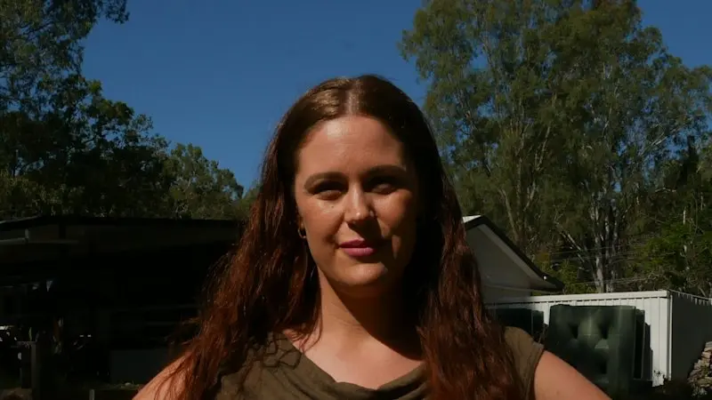
나탈리 테일러와 남편 제이크가 브리즈번 남쪽 로건 빌리지의 시골 부지를 구입했을 때, 장애를 가진 세 명의 자녀를 위한 안식처로 만들겠다는 원대한 계획을 세웠다.
그들은 자녀들이 성장하면 지원 주택에 들어갈 필요가 없도록 할머니용 별채를 지었다—부부는 이에 대해 확고히 반대했다.
하지만 나탈리와 제이크가 2025년 3월 해당 부지에 정착한 후, 부부는 그 계획을 실행하기가 더 어려워졌음을 깨달았다.
로건 시의회가 홍수 지도를 업데이트했고, 해당 부지는 이제 홍수 위험이 높은 것으로 간주되었다.
"모든 것을 읽어보니, 실제로 부지에 매우 엄격한 계획 제한을 부과했더라고요," 그녀가 말했다.
홍수 매핑과 그것이 재산 소유자에게 미치는 영향은 페이스북 그룹에서 진저리가 나도록 논의되는 로건에서 시의회에 대한 가장 큰 정치적 이슈가 되었다.
이달 초 전직 시장과 전직 하원의원은 시의회가 불법적으로 지도를 업로드했다고 비난했다. 존 레이븐 시장은 이 문제를 "일어나는 순간부터 잠들 때까지" 생각한다고 말했다.
지도는 2023년 이후 두 차례 업데이트되었으며, 모두 시가 계획에 영구적인 변경을 진행하면서 신속한 변경을 할 수 있게 하는 임시 지역 계획 명령(TLPI)을 사용했다.
테일러가 같은 처지에 있는 사람들이 얼마나 많은지 깨닫자, 그녀는 홍수 매핑 행동 그룹을 시작했고, 이는 현재 불만을 터뜨린 전직 시장 존 프리먼과 로건 납세자 협회와 연계되어 있다.
"우편으로 편지를 받았는데, 정말 스트레스를 많이 받은 사람들이 많았어요," 그녀가 말했다.
그녀는 많은 사람들이 보험료 청구서—일부는 연간 수천 달러나 올랐거나 보장이 완전히 취소된 경우—를 받았을 때 재산권이 변경되고 있음을 알았다고 말했다.
업데이트 이후 시의회는 주민들을 진정시키기 위해 필사적으로 노력해왔다. 이미 관련 회사들이 두 차례 검토한 지도는 현재 자문 서비스인 Restore Blue에 의해 다시 검토되고 있다.
사립 컨설팅 회사 StormFlood의 소유자인 홍수 엔지니어 마틴 루샤니-자르메흐리는 로건에서 광범위하게 일해왔으며, 새로운 지도가 훨씬 더 위험 회피적이라며 이는 나쁜 것이 아니라고 말했다.
하지만 그것은 토지 개발을 희망하는 토지 소유자에게 재정적 압력을 가한다.
"홍수 지도는 홍수 위험 인식을 대중에게 제공함으로써 목적을 달성하는데, 이것이 홍수평 관리자의 주요 목표입니다," 그가 말했다.
"다른 한편으로, 이러한 홍수 지도는 홍수 위험 지역의 개발 및 건설 작업에 상당히 제한적이 되었다."
"현재 계획적 관점에서 홍수 매핑이 적용되는 방식은 일부 상황에서 실제로 유연성이 없으며, 다른 때에는 심지어 비논리적일 수도 있다."
그는 시의회의 홍수 모델링이 시의회 요건을 충족하는 데 필요한 이미 비싼 엔지니어링 작업 외에 최대 5000달러까지 들 수 있다고 말했다.
"상세하고 부지별 조언의 비용은 쉽게 수천 달러에 달하며, 이는 대부분의 주거용 토지 소유자가 여유 있게 가지고 있지 않은 금액이다," 루샤니-자르메흐리가 말했다.
이러한 비용은 테일러 부부에게 치료사들이 어느 시점에 지원 생활이 필요할 것이라고 말한 적어도 한 명의 아들을 위한 작은 집을 짓는 꿈을 위협하고 있다.
"우리가 어떻게 그걸 감당할 수 있을지 모르겠어요—가족들에게 현실적이지 않아요," 테일러가 말했다.
루샤니-자르메흐리는 정부가 기후 변화의 영향과 미래에 있을 더 크고 빠른 홍수를 고려해야 하므로 홍수 매핑은 끊임없이 변화하는 분야라고 말했다.
"후에 생각해 보면, 오늘날 같은 홍수 모델 데이터를 그때 가지고 있었다면, 특히 주거용 부지의 경우 이러한 방식으로 구역이 지정된 일부 부지를 보지 않았을 것이다," 그가 말했다.
대변인은 로건 시의회가 홍수 지도의 영향을 받은 토지 소유자의 소규모 개발 부담을 완화하기 위해 노력하고 있다고 말했다.
시의회는 2월에 시작된 Restore Blue 조사가 대략 3개월이 소요될 것이라고 밝혔다.
처리 완료
192 tokens · $0.0004
기사 수집 완료 · 04:05
매체 피드에서 기사 메타데이터 수집
헤드라인 번역 완료 · 04:19
제목/요약 한국어 번역 (fetch 시점 inline)
kimi-k2.5
192 tokens
$0.00037
4.1s
본문 추출 완료
4,156자 추출 완료
본문 한국어 번역 완료 · 04:19
1,948자 번역 완료
지정학적 엔티티 추출 완료 · 04:19
0개 엔티티 추출 완료
The updated maps, already reviewed twice, are being looked at again by an independent advisor as the council deals with the fallout of the widespread changes.
When Natalie Taylor and her husband Jake bought a rural block in Logan Village, south of Brisbane, they had grand plans to make it a sanctuary for their children, three of whom have disabilities.They had built a granny flat so when their kids grew older, they would never need to go into supported housing – something the parents were staunchly against.
But Natalie and Jake settled on the property in March 2025, the couple realised those plans had become more difficult to pull off.
Logan City Council updated their flood maps, and the property as now considered at high risk of flooding.
“We were reading through it all, and it actually imposed really strict planning restrictions on the property,” she said.
Flood mapping, and its effect on property owners, has become the single biggest political issue for the council in Logan, where Facebook groups discuss it ad nauseam.
Earlier this month a former mayor and a former MP accused the council of illegally uploading maps. Mayor Jon Raven said he thinks about the issue “from the moment I wake up until I go to bed”.
The maps have been updated twice since 2023, both times using temporary local planning instruments (TLPIs) that allow the council to make fast changes as they undertake permanent changes to the city plan.
When Taylor realised how many people were in the same boat, she started a flood mapping action group, now linked to the disgruntled former mayor John Freeman and the Logan Ratepayers Association.
“We were receiving letters in the mail, and there were a lot of us who were really stressed out,” she said.
She said many people only realised their property rights were changing when they got their insurance bills, some of which had jumped by thousands of dollars annually, or had their coverage cancelled completely.
Since the update, the council has been desperate to calm residents. The maps, already reviewed twice by companies involved in the process, are now being looked at again by the advisory service Restore Blue.
Flood engineer Martin Roushani-Zarmehri, owner of the private consultancy StormFlood, has worked extensively in Logan, and said the new maps are much more risk-averse, which is not a bad thing.
But they do put financial pressure on landholders hoping to develop their land.
“Flood maps achieve their purpose by providing flood risk awareness to the public, which is the primary goal of floodplain managers,” he said.
“On the other hand, these flood maps have become quite prohibitive to development and building works on flood-prone land.
“How the flood mapping is currently being applied in a planning sense is indeed inflexible in some situations, and at other times can even be illogical.”
He said the council’s flood modelling can cost up to $5000, on top of already expensive engineering work required to meet the council’s needs.
“The price of detailed and site-specific advice do easily run into the thousands of dollars, which most residential landowners don’t have spare,” Roushani-Zarmehri said.
These costs hang over the Taylors’ dream of building a small home for at least one of their sons, who therapists have said will likely need to live in supported living at some stage.
“I don’t see how we’re going to be able to afford that – it’s not realistic for families,” Taylor said.
Roushani-Zarmehri said flood mapping was a constantly changing space, as governments must account for the effects of climate change and the bigger, faster floods the future likely holds.
“In hindsight, if we had the same flood model data today as we did back then, we wouldn’t be seeing some of these properties zoned the way they have, especially residential properties,” he said.
A spokesperson said Logan City Council was working to ease the burden of the small developments on landholders affected by the flood maps.
The council has said the Restore Blue investigation, which began in February, would take roughly three months.
Start the day with a summary of the day’s most important and interesting stories, analysis and insights.
You have reached your maximum number of saved items.
Remove items from your saved list to add more.