위성 이미지 제공업체, 미국의 압력으로 이란 이미지 제한 후 우려 제기
Concerns after satellite provider restricts Iran images following US pressure
BBC News
EN
2026-04-11 14:40
Translated
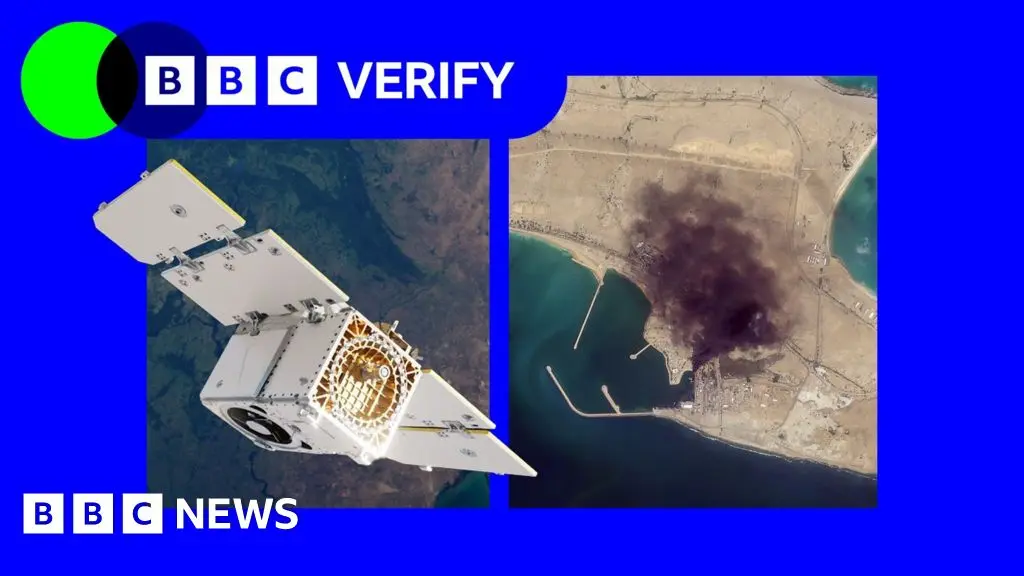
Planet Labs가 이란과 중동 일부 지역에 대한 위성 이미지 접근을 무기한 제한하고 있습니다.
미국 정부의 요청에 따라 주요 위성 이미지 회사가 이란과 중동 대부분 지역의 이미지 접근을 제한한다고 발표한 후 인도주의 단체와 기자들이 우려를 표시했습니다.
캘리포니아에 본사를 둔 Planet Labs는 처음에 3월에 해당 지역의 새로운 이미지 제공을 14일 지연하기로 했습니다. 이후 "무기한" 제한으로 전환했습니다.
이 결정으로 기자, 인도주의 단체 및 분석가들이 위성 이미지를 사용하여 미국-이스라엘의 이란과의 전쟁의 영향, 군사 목표물 및 민간 기반시설에 대한 피해를 평가하는 능력이 제한되었습니다.
미국이 Planet에 취재를 중단하도록 압력을 가한 이유는 불명확하며 국방부는 논평 요청에 응하지 않았습니다.
Planet은 원래 14일 지연 정책이 "우리의 이미지가 적대적 행위자들에 의해 전술적으로 활용되어 동맹국 및 NATO 파트너 인원과 민간인을 겨냥하는 것을 보장하기 위함"이라고 말했습니다.
BBC Verify에 보낸 성명에서 "관리된 배포" 시스템으로 전환하여 "보안 위험이 감소할 때까지" 선택된 이미지를 "일회성 기준으로" 공유할 것이라고 밝혔습니다.
제한의 범위를 명시하기를 거부했습니다. 그러나 BBC Verify의 포털 접근을 바탕으로 제한은 이라크, 레바논, 이스라엘 및 가자를 포함한 중동 대부분으로 확대되는 것으로 보입니다.
한 위성 이미징 전문가는 BBC Verify에 Planet과 같이 군사 계약을 보유한 회사들이 때때로 실제로는 "상업적 인센티브 구조에 의해 주도되는" "자발적 준수" 요청을 이행할 수 있다고 말했습니다.
BBC Verify는 2월 말 이란에서의 전쟁이 시작된 이후 이란의 미나브 마을 학교에 대한 미국 공습 때와 같이 중동 전역에서 Planet 이미지를 사용해 보도했습니다.
이제 3월 9일 이후에 촬영된 이미지는 회사의 클라이언트에게 더 이상 일상적으로 제공되지 않습니다.
위성 이미지는 CNN, Financial Times 및 BBC에서 일한 조사 기자 Benjamin Strick에 따르면 기자들을 위한 핵심 도구가 되었습니다.
이는 특히 "기자들이 안전하게 현장에 접근할 수 없거나 정보가 엄격히 통제되는 분쟁 지역, 재해 및 기타 접근 제한 환경"에 해당합니다.
Planet의 사업 모델은 업계의 다른 회사들과 유사합니다. 미국 국방 부문과의 작업을 확대해 왔으며, 미국 국가지리정보국 및 자회사를 통한 미국 해군과 협력하고 있습니다. 또한 독일과 스웨덴 군대와도 협력합니다.
이전의 Maxar로 알려진 Vantor는 미국 육군 및 미국 우주군과의 계약이 있으며 미국 군사 기지에 대한 취재를 제한합니다. 그러나 로이터에 펜타곤 관계자들로부터 이란 취재 제한을 요청받지 않았다고 이번 주 초 밝혔습니다.
Maxar에서 이전에 근무했고 비영리 위성 서비스 Common Space를 공동 설립한 지리공간 분석가 Bill Greer는 Planet과 같은 회사들이 보유한 국방 계약의 수가 정부에 일정 정도의 영향력을 부여한다고 지적했습니다.
"우리가 지금 목격하고 있는 것은 법적 명령이 아닌 상업적 인센티브 구조에 의해 주도되는 자발적 준수입니다"라고 그는 BBC Verify에 말했습니다.
"가장 큰 고객이 또한 당신을 규제하는 정부일 때, 자발적과 비자발적 사이의 경계선은 매우 얇아집니다."
Greer는 또한 인도주의 단체들이 위성 이미지 제한의 영향을 받는다고 지적했습니다.
"전체 지역이 무기한 어두워지면, 그것은 [그들의] 대피 계획, 피해 평가, 인권 침해 기록 및 원조 제공 조율 능력에 직접 영향을 미칩니다"라고 그는 말했습니다.
자선 단체 Oxfam은 BBC Verify에 위성 이미지를 사용하여 실시간 분쟁 및 재해 중에 일부 물류를 계획한다고 말했습니다.
단체의 인도주의 담당자 Magnus Corfixen은 Planet이 취재도 중단한 가자에서 위성 서비스가 물, 위생 및 위생(WASH) 프로그램을 운영하는 데 도움이 되었다고 말했습니다.
"우리는 이 수도 시스템에 개인적으로 접근할 수 없었습니다"라고 그는 말했습니다. "그래서 우리는 위성 이미지를 사용하여 그들이 여전히 작동 중인지 또는 파괴되었는지 확인하려고 시도했습니다."
그는 이미지 검토를 바탕으로 Oxfam이 스트립으로 운송해야 할 장비를 계획했다고 덧붙였습니다.
BBC Verify는 또한 이스라엘이 미디어가 독립적으로 기자를 스트립으로 보내는 것을 허용하지 않기 때문에 가자의 변화와 피해를 보도하기 위해 위성 이미지에 의존했습니다. 이전에 가자에서 이미지 지연이 있었지만 이 정도의 수준은 없었습니다.
미국 공군 전직 대위이자 American Enterprise Institute의 선임 연구원 Todd Harrison은 BBC Verify에 이란 군이 제한된 위성 감시 능력을 가지고 있어 러시아, 중국 및 "상업 제공자로부터 획득할 수 있는 모든 이미지"에 크게 의존하고 있다고 말했습니다.
"미국 및 유럽 상업 회사들은 세계에서 최고의 우주 감시 능력을 가지고 있습니다"라고 그는 말했습니다.
"이 데이터는 중동 전역에서 목표물을 공격하려는 이란의 노력과 공격 효과를 평가하려는 노력에 매우 귀중할 것입니다."
또한 나쁜 행위자들이 이란 이미지에 대한 제한을 악용하여 온라인에서 위조물을 증식시킨다는 우려도 제기되었습니다.
호주 매핑 플랫폼 Soar.Atlas의 설립자 Amir Farhand는 BBC Verify에 이 분쟁 중에 "위조 위성 이미지의 대규모 급증"을 추적했으며 이 추세가 "심각한 문제가 되고 있다"고 말했습니다.
Planet의 서비스가 부재한 상황에서 BBC 및 New York Times와 같은 뉴스 클라이언트들이 미국 이외의 솔루션으로 전환했습니다.
그러나 New York Times의 시각 조사 기자 Christoph Koettl은 유럽우주청과 같은 일부 서비스가 제공하는 해상도가 같은 수준의 세부사항이나 광범위한 취재를 제공하지 않는다고 말했습니다.
"이미지가 더 흐립니다. 자동차, 차량 등을 구별할 수 없습니다"라고 그는 말했습니다. "Planet Labs와 같은 제공자의 경우, 장점은 그들이 거의 모든 지구상의 장소를 하루에 한 번 이미징한다는 것입니다."
Harrison은 Planet에 요청된 것과 같은 제한이 더 일반화될 것으로 예상하지만, 업계가 확대되고 전 세계에 새로운 제공자가 등장하면서 점점 더 무용지물이 될 것으로 예상한다고 말했습니다.
"이와 같은 이중용도 기술이 점점 더 민주화되었기 때문에, 그것은 현대의 전장을 양측 모두에게 이전보다 더 투명하게 만들고 있습니다"라고 그는 말했습니다.
"그것은 미국 및 기타 국가들이 군사 작전을 계획하고 수행하는 방식에 적응해야 할 인생의 사실입니다."
BBC Verify에서 조사하기를 원하는 주장은 무엇입니까?
처리 완료 5,284 tokens · $0.0153
기사 수집 완료 · 15:00
매체 피드에서 기사 메타데이터 수집
헤드라인 번역 완료 · 15:15
제목/요약 한국어 번역 (fetch 시점 inline)
claude-haiku-4-5-20251001
178 tokens
$0.00045
1.9s
본문 추출 완료
6,592자 추출 완료
본문 한국어 번역 완료 · 15:15
3,325자 번역 완료
claude-haiku-4-5-20251001
5,106 tokens
$0.01488
33.3s
지정학적 엔티티 추출 완료 · 15:15
8개 엔티티 추출 완료
Planet Labs says it is restricting coverage of Iran and parts of the Middle East indefinitely.
Humanitarian organisations and journalists have expressed concerns after a leading satellite imagery company told its users it was restricting access to images of Iran and large parts of the Middle East following a request from the US government.California-based Planet Labs initially introduced a 14-day delay on providing new imagery from the region in March. It has since moved to an "indefinite" restriction.
The decision has limited how journalists, humanitarian groups and analysts can use satellite images to assess the impact of the US-Israel war with Iran, including damage to military targets and civilian infrastructure.
It is unclear what prompted the US to press Planet to suspend its coverage and the Department of Defense did not respond to a request for comment.
Planet initially said its original 14-day delay policy was "to ensure our imagery is not tactically leveraged by adversarial actors to target allied and Nato-partner personnel and civilians".
It said in a statement to BBC Verify that it was now switching to a system of "managed distribution" and would share selected images "on a one-off basis until the security risk has abated".
It declined to say how extensive the restrictions were. But based on BBC Verify's access to the portal it appears to extend across most of the Middle East, including Iraq, Lebanon, Israel and Gaza.
One satellite imaging expert told BBC Verify that companies like Planet that have military contracts can sometimes implement "voluntary compliance" requests that are actually "driven by commercial incentive structures".
BBC Verify has used Planet imagery across the Middle East in its reporting, including since the war in Iran began at the end of February - such as when a US strike on a school in the Iranian town of Minab.
The changes now mean that images taken after 9 March are no longer routinely available to the company's clients.
Satellite imagery has become a key tool for reporters, according to investigative journalist Benjamin Strick, who has worked for CNN, the Financial Times and the BBC.
This is especially true for "conflict zones, disasters and other restricted environments where reporters cannot safely access the scene or where information is tightly controlled", he said.
Planet's business model is similar to others in the industry. It has been expanding its work with the US defence sector, including the US National Geospatial Intelligence Agency and - through a subsidiary - the US Navy. It also works with the German and Swedish militaries.
Vantor, formerly known as Maxar, has contracts with the US Army and US Space Force and limits coverage of US military bases. However, it told Reuters earlier this week that it had not been asked by Pentagon officials to restrict its coverage of Iran.
Bill Greer, a geospatial analyst who previously worked at Maxar and co-founded the non-profit satellite service Common Space, noted that the number of defence contracts held by companies like Planet grants governments some degree of influence over them.
"What we're seeing now is voluntary compliance driven by commercial incentive structures, not legal mandates," he told BBC Verify.
"When your largest customer is also the government that regulates you, the line between voluntary and involuntary gets very thin."
Greer also observed that humanitarian groups were affected by restrictions on satellite images.
"When an entire region goes dark indefinitely, it directly affects [their] ability to plan evacuations, assess damage, document human rights abuses and co-ordinate aid delivery," he said.
The charity Oxfam told BBC Verify it used satellite imagery to plan some of its logistics during live conflicts and disasters.
The group's humanitarian lead, Magnus Corfixen, said that in Gaza - where Planet has also suspended coverage - satellite services helped it to run its water, sanitation and hygiene (Wash) programme.
"We couldn't access these water systems in person," he said. "So we tried to use satellite imagery to see whether or not they were still operational or if they had been destroyed."
He added that, based on reviews of the imagery, Oxfam then planned what equipment they needed to transport into the Strip.
BBC Verify has also relied on satellite imagery to report on changes and damage in Gaza, since Israel does not allow media to send journalists independently into the Strip. There have previously been delays on imagery from Gaza, but never to this extent.
Todd Harrison - a senior fellow at the American Enterprise Institute and ex-US Air Force captain - told BBC Verify that the Iranian military had limited satellite surveillance capability of its own, making it heavily reliant on Russia, China and "whatever imagery they can acquire from commercial providers".
"US and European commercial firms have some of the best space surveillance capabilities in the world," he said.
"This data would be enormously valuable to Iran in its efforts to strike targets across the Middle East... and to assess the effectiveness of its strikes."
There have also been concerns that bad actors have also seized on the restrictions placed on Iranian imagery to proliferate fakes online.
Amir Farhand - founder of Soar.Atlas, an Australian mapping platform that uses satellite images - told BBC Verify that it had tracked "a massive spike in fake satellite imagery during this conflict", adding that the trend was "becoming a serious problem".
In the absence of Planet's services, its news clients - such as the BBC and the New York Times - have been turning to non-US based solutions.
But Christoph Koettl, a visual investigations journalist with the New York Times, said that the resolution offered by some of these services - like the European Space Agency - did not offer the same level of detail or widespread coverage.
"The imagery is blurrier. I cannot distinguish between cars, vehicles, things like that," he said. "With a provider like Planet Labs, the advantage is that they're imaging almost every place on Earth once a day."
Harrison said he expects restrictions like those requested of Planet to become more common, but increasingly more futile as the industry expands and new providers emerge across the globe.
"Because dual-use technology like this has become increasingly democratised, it is making the modern battlefield more transparent for both sides than ever before," he said.
"That is a fact of life the US and others will have to adapt to in how they plan and conduct military operations."
What claims do you want BBC Verify to investigate?