역사적인 삼각측량 기점의 문화재 등록 추진...영국 지도 제작의 토대가 된 기념비
Campaigners seek listed status for historic trig points that mapped Britain
The Guardian
· 🇬🇧 London, GB
Matthew Weaver
EN
2026-04-17 00:00
Translated
노샘프턴셔 콜드 애쉬비와 컴브리아 토니 게일의 기둥이 현대식 지도 제작을 가능하게 한 프로젝트의 시작과 끝을 상징한다
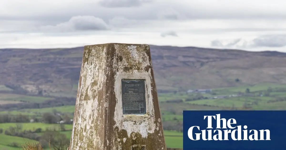
문화유산 보호 운동가들이 "시골의 소박한 근대성의 오벨리스크"라 불리는 두 개의 콘크리트 기둥에 대한 문화재 등록을 추진하고 있다.
이 기능적인 120cm(4피트) 높이의 석재 또는 콘크리트 "삼각측량 기점(trig points)"은 현대 지도 제작 발전에 필수적이었던 6,500개의 측량 기둥 네트워크의 일부를 이루었다.
GPS와 드론의 등장으로 이제는 쓸모없게 되었지만, 여전히 등산객들의 이정표이자 수많은 정상 단체 사진과 셀카의 초점이 되고 있다. 심지어 모든 기점을 방문하려는 이들 사이에서 '트리그 배깅(trig-bagging)'이라는 틈새 취미까지 생겨났다.
현대 건축과 디자인 보존을 위해 활동하는 20세기 학회(C20)는 이 기둥들 중 처음과 마지막으로 사용된 두 기점에 대한 문화재 등록을 신청했다.
이 두 삼각측량 기점은 '영국 재삼각측량(Retriangulation of Great Britain)'이라는 야심 찬 지도 제작 및 기준점 프로젝트의 시작과 끝을 상징한다.
첫 번째 기점은 90년 전 이번 주에 노샘프턴셔 콜드 애쉬비에 세워졌다. 지도 애호가와 트리그 배거들에게 이곳의 격자 좌표는 SP 64422 76588이다. 마지막 관측은 1962년 6월 4일 컴브리아 토니 게일(NY 82516 13912)에서 이루어졌다. C20은 두 기점 모두 2급 문화재로 보호받도록 영국 문화유청(Historic England)에 신청서를 제출했다.
삼각측량 기점은 마틴 호틴 준장이 설계했다. 그는 제1차 세계대전 참전 용사이자 전 공병대 장교로, 측량국(OS)을 위해 재삼각측량 프로젝트를 이끌었다.
호틴 기둥(Hotine Pillars)으로도 불리는 이 점점 가늘어지는 기둥들은 영국 제도를 정밀하게 측량하는 데 사용된 경위의(theodolite)를 고정하기 위한 황동판이 상단에 있었다. 강풍 속에서 경위의를 고정하기 위한 황고리도 달려 있었다.
맑은 날에는 어떤 기점에서도 최소 두 개의 다른 기점이 보였다. 이를 통해 호틴의 팀은 삼각형 네트워크를 이용해 전국을 지도에 담을 수 있었다.
수백 개의 기점은 건설 개발, 농업, 해안 침식으로 사라졌고, 문화재로 등록된 것은 하나도 없다. 1990년대 측량국은 유지보수 비용 절감을 위해 불필요한 기둥 제거를 제안했다.
그러나 램블러스(Ramblers)를 포함한 운동가들의 반발 이후 측량국은 철거 계획을 철회했다. 대신 유지보수 책임이 지역 단체로 이전되었다. 수천 개의 기점이 고지대의 랜드마크로 남아 있다. 가장 높은 곳은 스코틀랜드 벤 네비스 정상에 있다.
C20의 신청서는 삼각측량 기둥이 이제 "거의 쓸모없게 되었지만", "여전히 등산객들의 이정표 역할을 하며 영국 시골의 상징"이라고 인정한다.
신청서는 이들의 문화적 중요성이 과거의 기능적 용도를 넘어선다고 주장한다. 미국 작가 빌 브라이슨은 그의 저서 '리틀 드리블링 가는 길(The Road to Little Dribbling)'에서 삼각측량 기점을 그의 "가장 좋아하는 영국 물건" 중 하나로 꼽았다.
이들은 또한 전 인디 레코드 레이블인 앵귤러 레코딩 코퍼레이션(Angular Recording Corporation)의 이름과 로고에 영감을 주었는데, 이 레이블은 블록 파티(Bloc Party)와 롱 블론데스(the Long Blondes) 등 여러 밴드를 데뷔시켰다.
신청서 결론에서 C20은 "시골의 이러한 근대성의 현대 오벨리스크들은 전례 없는 규모의 전국적 측량 프로젝트의 유산이다. 우리는 영국 문화유청이 이 보석을 영국 국가문화유산 목록에 합당한 자리에 올려주기를 촉구한다"고 밝혔다.
C20의 디렉터 캐서린 크로프트는 "GPS, 위성 기술, 휴대전화의 내비게이션 앱이 생기기 훨씬 전에, 삼각측량 기점은 한 국가를 지도에 담은 소박한 콘크리트 기둥이었다"고 말했다.
"영국의 재삼각측량이 90주년을 맞이하는 가운데, 우리는 상징적인 지도 핀을 꽂을 기회를 포착해 가장 역사적으로 중요한 두 삼각측량 기점, 즉 처음과 마지막 예시를 국가 문화유산으로 등록하도록 신청했다"고 덧붙였다.
"강한 바람 속에서 삼각측량 기점 위에 서는 소박한 승리감을 능가하는 것은 없다. 우리는 시골의 이 두 현대 콘크리트 오벨리스크가 곧 문화·미디어·스포츠부의 인정을 받기를 희망한다."
처리 완료
391 tokens · $0.0008
기사 수집 완료 · 00:21
매체 피드에서 기사 메타데이터 수집
헤드라인 번역 완료 · 00:39
제목/요약 한국어 번역 (fetch 시점 inline)
kimi-k2.5
391 tokens
$0.00081
8.9s
본문 추출 완료
3,834자 추출 완료
본문 한국어 번역 완료 · 00:39
2,101자 번역 완료
지정학적 엔티티 추출 완료 · 00:39
0개 엔티티 추출 완료
Pillars at Cold Ashby, Northamptonshire, and Thorny Gale, Cumbria, bookended the project that modernised mappingHeritage campaigners are bidding for listing status for two concrete pillars hailed as “modest obelisks of modernity in the countryside”.These functional 120cm (4ft) stone or concrete “trig points” formed part of a 6,500-strong network of surveying posts that were vital for the development of modern mapping.
Heritage campaigners are bidding for listing status for two concrete pillars hailed as “modest obelisks of modernity in the countryside”.These functional 120cm (4ft) stone or concrete “trig points” formed part of a 6,500-strong network of surveying posts that were vital for the development of modern mapping.
They have since been rendered obsolete by GPS and drones but are still beacons for walkers and the focal points of countless hilltop group photos and selfies. They have even sparked a niche hobby of trig-bagging for those intent on visiting all of them.
Now the Twentieth Century Society (C20), which campaigns to preserve modern architecture and design, has applied for listing status for the first and last of these posts to be used.
These two trig points bookend an ambitious mapping and reference project – the Retriangulation of Great Britain.
The first was built 90 years ago this week in Cold Ashby, Northamptonshire. For mapping aficionados and trig baggers, it is at grid reference: SP 64422 76588. The final observation was taken on 4 June 1962 at Thorny Gale in Cumbria (NY 82516 13912). C20 has submitted an application to Historic England for both to be protected under Grade II-listed status.
Trig points were designed by Brig Martin Hotine – a former Royal Engineers officer and veteran of the first world war, who led the retriangulation project for the Ordnance Survey (OS).
Sometimes referred to as Hotine Pillars, these tapered posts were topped with a brass plate for fixing theodolites – precision instruments used by surveyors to accurately map the British Isles. They came with brass loops for tying down theodolites in high winds.
On a clear day it was once possible to see at least two other trig points from any other – allowing Hotine’s team to map the whole country using a network of triangles.
Hundreds have been lost to building development, farming and coastal erosion, and none have been listed. In the 1990s, OS suggested removing unwanted pillars to save maintenance costs.
But after a backlash from campaigners, including the Ramblers, OS withdrew the demolition plan. Instead, responsibility for maintenance was transferred to local groups. Thousands remain as landmarks on high ground – the highest is on the summit of Scotland’s Ben Nevis.
C20’s application acknowledges that trig pillars are now “more or less obsolete”, but “they still act as a beacon for ramblers and are a symbol of the British countryside.”
It argues their cultural importance goes beyond their former functional use. The American writer Bill Bryson listed trig points as one of his “favourite British items” in his book, The Road to Little Dribbling.
They also inspired the name and logo of the former indie record label the Angular Recording Corporation, which launched several bands including Bloc Party and the Long Blondes.
In a conclusion to the application, C20 said: “These modern obelisks to modernity in the countryside are remnants from a nationwide surveying project of unprecedented scale. We urge Historic England to award this gem its deserved place on the national heritage list for England.”
Catherine Croft, director of the C20, said: “Long before GPS, satellite technology and navigational apps on our mobile phones, trig points were the humble concrete pillars that mapped a nation.
“As the landmark Retriangulation of Great Britain celebrates its 90th anniversary, we spied an opportunity to put a figurative pin-in-the-map and have submitted the two most historically important trig points – the first and last examples – to be nationally listed.
“Nothing beats the modest triumph of standing on top of a trig point in a brisk wind and we hope these two modern obelisks of concrete in the countryside will soon be recognised by the Department for Culture, Media and Sport.”